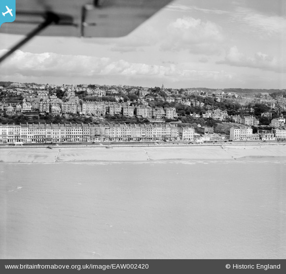
EAW002420 ENGLAND (1946). The seafront and town at Marina to the west of the ruins of the bomb-damaged parish church, St Leonards, from the south, 1946
    © Copyright OpenStreetMap contributors and licensed by the OpenStreetMap Foundation. 2025. Cartography is licensed as CC BY-SA.
  
Nearby Images (8)
Details
| Title | [EAW002420] The seafront and town at Marina to the west of the ruins of the bomb-damaged parish church, St Leonards, from the south, 1946 | 
| Reference | EAW002420 | 
| Date | 16-October-1946 | 
| Link | |
| Place name | ST LEONARDS | 
| Parish | |
| District | |
| Country | ENGLAND | 
| Easting / Northing | 579544, 108632 | 
| Longitude / Latitude | 0.55084640662406, 50.848746014425 | 
| National Grid Reference | TQ795086 | 
Pins
Be the first to add a comment to this image!
User Comment Contributions
| The church was hit by a damaged V1 'Doddlebug' flying bomb which had been hit out at sea and eventually crashed at the front of the church without a single casualty on the ground. The church was rebuilt between 1953 and 1961 by by Sir Giles Scott and A G Scott. See the church website at http://www.stleonardstethelburga.org.uk/welcome.htm |   John W | Thursday 4th of May 2017 05:55:22 PM | 
 
             
  ![[EAW002420] The seafront and town at Marina to the west of the ruins of the bomb-damaged parish church, St Leonards, from the south, 1946](http://britainfromabove.org.uk/sites/all/libraries/aerofilms-images/public/100x100/EAW/002/EAW002420.jpg) 
  
                                          ![[EPW026211] The Palace Pier and Hastings Pier and seafront, Hastings, from the west, 1929](http://britainfromabove.org.uk/sites/all/libraries/aerofilms-images/public/100x100/EPW/026/EPW026211.jpg) 
 ![[EPW000755] The Promenade and Palace Pier, St Leonards, from the west, 1920](http://britainfromabove.org.uk/sites/all/libraries/aerofilms-images/public/100x100/EPW/000/EPW000755.jpg) 
 ![[EAW002419] The seafront and town centred upon the ruins of the bomb-damaged parish church, St Leonards, from the south, 1946](http://britainfromabove.org.uk/sites/all/libraries/aerofilms-images/public/100x100/EAW/002/EAW002419.jpg) 
 ![[EAW002421] The seafront and town at Sussex Road and Marina, St Leonards, from the south, 1946](http://britainfromabove.org.uk/sites/all/libraries/aerofilms-images/public/100x100/EAW/002/EAW002421.jpg) 
 ![[EPW000106] The Marina (Road), Hastings, 1920](http://britainfromabove.org.uk/sites/all/libraries/aerofilms-images/public/100x100/EPW/000/EPW000106.jpg) 
 ![[EPW026194] Marina, West Hill and environs, St Leonards, from the south, 1929](http://britainfromabove.org.uk/sites/all/libraries/aerofilms-images/public/100x100/EPW/026/EPW026194.jpg) 
 ![[EPW035335] The Palace Pier and town, St Leonards, from the south-west, 1931](http://britainfromabove.org.uk/sites/all/libraries/aerofilms-images/public/100x100/EPW/035/EPW035335.jpg)