
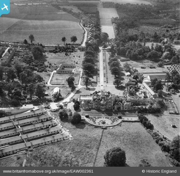
EAW002361 ENGLAND (1946). Preston Hall Sanatorium at the British Legion Village, Aylesford, 1946
© Copyright OpenStreetMap contributors and licensed by the OpenStreetMap Foundation. 2026. Cartography is licensed as CC BY-SA.
Nearby Images (7)
EAW002361

EAW002364

EAW002359

EAW002363

EAW002360

EAW002362

EAW002358

Details
| Title | [EAW002361] Preston Hall Sanatorium at the British Legion Village, Aylesford, 1946 |
| Reference | EAW002361 |
| Date | 9-September-1946 |
| Link | |
| Place name | AYLESFORD |
| Parish | AYLESFORD |
| District | |
| Country | ENGLAND |
| Easting / Northing | 572807, 157970 |
| Longitude / Latitude | 0.47881105712711, 51.294091155864 |
| National Grid Reference | TQ728580 |
Pins

Kentishman |
Thursday 18th of March 2021 04:48:51 PM | |
|
Kentishman |
Saturday 27th of February 2016 03:10:04 PM | |
|
Kentishman |
Saturday 27th of February 2016 02:58:26 PM | |
|
Kentishman |
Saturday 27th of February 2016 02:56:28 PM | |
|
Kentishman |
Wednesday 17th of February 2016 06:11:41 PM |
User Comment Contributions

Two aspects of importance in this image. First Preston Hall was used as a chest hospital during WW1, treating soldiers who had been gassed or contracted tuberculosis. Secondly, in the distance, along Hermitage Lane, are the small bungalows erected for disabled service men from WW1, known initially as The Colony, and later as British Legion Village. |
Kentishman |
Saturday 27th of February 2016 02:31:35 PM |