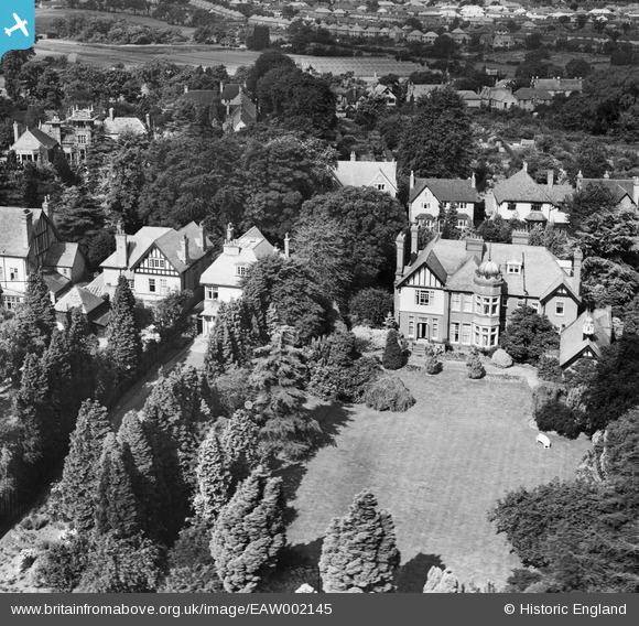
EAW002145 ENGLAND (1946). Houses on St Bernards Road, Kineton Green, 1946
© Copyright OpenStreetMap contributors and licensed by the OpenStreetMap Foundation. 2025. Cartography is licensed as CC BY-SA.
Nearby Images (7)
Details
| Title | [EAW002145] Houses on St Bernards Road, Kineton Green, 1946 |
| Reference | EAW002145 |
| Date | 1-August-1946 |
| Link | |
| Place name | KINETON GREEN |
| Parish | |
| District | |
| Country | ENGLAND |
| Easting / Northing | 413101, 281429 |
| Longitude / Latitude | -1.8072922793146, 52.430309235418 |
| National Grid Reference | SP131814 |
Pins
Be the first to add a comment to this image!


![[EAW002145] Houses on St Bernards Road, Kineton Green, 1946](http://britainfromabove.org.uk/sites/all/libraries/aerofilms-images/public/100x100/EAW/002/EAW002145.jpg)
![[EAW002146] Houses on St Bernards Road, Kineton Green, 1946](http://britainfromabove.org.uk/sites/all/libraries/aerofilms-images/public/100x100/EAW/002/EAW002146.jpg)
![[EAW001820] Houses off St Bernards Road and Olton Reservoir, Kineton Green, 1946](http://britainfromabove.org.uk/sites/all/libraries/aerofilms-images/public/100x100/EAW/001/EAW001820.jpg)
![[EAW001817] Walverle House off St Bernards Road and Olton Reservoir, Kineton Green, 1946](http://britainfromabove.org.uk/sites/all/libraries/aerofilms-images/public/100x100/EAW/001/EAW001817.jpg)
![[EAW001821] Houses off St Bernards Road, Kineton Green, 1946](http://britainfromabove.org.uk/sites/all/libraries/aerofilms-images/public/100x100/EAW/001/EAW001821.jpg)
![[EAW001819] Houses off St Bernards Road, Kineton Green, 1946](http://britainfromabove.org.uk/sites/all/libraries/aerofilms-images/public/100x100/EAW/001/EAW001819.jpg)
![[EAW001818] Houses and the Cricket Ground off St Bernards Road, Kineton Green, 1946](http://britainfromabove.org.uk/sites/all/libraries/aerofilms-images/public/100x100/EAW/001/EAW001818.jpg)