
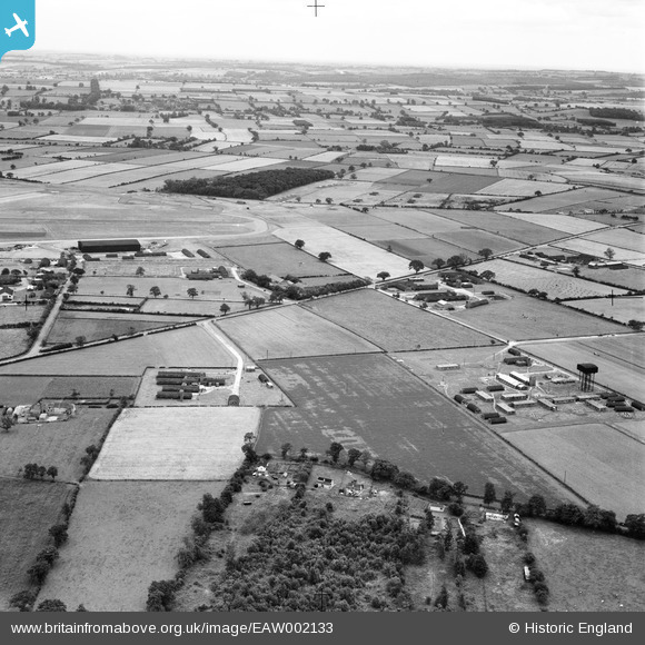
EAW002133 ENGLAND (1946). Wombleton Airfield, Wombleton, from the north, 1946
© Copyright OpenStreetMap contributors and licensed by the OpenStreetMap Foundation. 2026. Cartography is licensed as CC BY-SA.
Nearby Images (2)
EAW002133

EAW002129

Details
| Title | [EAW002133] Wombleton Airfield, Wombleton, from the north, 1946 |
| Reference | EAW002133 |
| Date | 1-August-1946 |
| Link | |
| Place name | WOMBLETON |
| Parish | WOMBLETON |
| District | |
| Country | ENGLAND |
| Easting / Northing | 466436, 483216 |
| Longitude / Latitude | -0.98048455527994, 54.240161256287 |
| National Grid Reference | SE664832 |
Pins

Matt Aldred edob.mattaldred.com |
Wednesday 31st of March 2021 04:58:15 PM | |
|
Matt Aldred edob.mattaldred.com |
Wednesday 31st of March 2021 04:57:30 PM | |
|
Matt Aldred edob.mattaldred.com |
Wednesday 31st of March 2021 04:57:24 PM | |
|
Matt Aldred edob.mattaldred.com |
Wednesday 31st of March 2021 04:57:12 PM | |
|
Matt Aldred edob.mattaldred.com |
Wednesday 31st of March 2021 04:56:47 PM | |
|
Matt Aldred edob.mattaldred.com |
Wednesday 31st of March 2021 04:56:34 PM | |
|
Matt Aldred edob.mattaldred.com |
Wednesday 31st of March 2021 04:55:54 PM | |

Debz |
Sunday 13th of July 2014 03:34:32 PM | |
|
Debz |
Sunday 13th of July 2014 03:34:01 PM | |
|
Debz |
Saturday 12th of July 2014 06:20:09 PM | |
|
Debz |
Saturday 12th of July 2014 06:19:45 PM | |
|
Debz |
Saturday 12th of July 2014 06:18:09 PM | |
|
Debz |
Saturday 12th of July 2014 06:17:36 PM | |
|
Debz |
Saturday 12th of July 2014 06:17:06 PM | |
|
Debz |
Saturday 12th of July 2014 06:16:41 PM |