
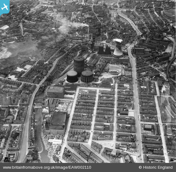
EAW002110 ENGLAND (1946). Portwood Gas Works and environs, Stockport, 1946
© Copyright OpenStreetMap contributors and licensed by the OpenStreetMap Foundation. 2026. Cartography is licensed as CC BY-SA.
Nearby Images (10)
EAW002110

EAW002111

EAW002116

EAW002114

EAW002113

EAW002115

EAW002112

EAW002109

EAW002118

EAW002117

Details
| Title | [EAW002110] Portwood Gas Works and environs, Stockport, 1946 |
| Reference | EAW002110 |
| Date | 1-August-1946 |
| Link | |
| Place name | STOCKPORT |
| Parish | |
| District | |
| Country | ENGLAND |
| Easting / Northing | 390155, 390746 |
| Longitude / Latitude | -2.1481308003511, 53.413171002836 |
| National Grid Reference | SJ902907 |
Pins

seikoman |
Sunday 15th of September 2024 08:51:32 PM | |
|
guisto11 |
Monday 14th of March 2022 06:47:01 PM | |
|
guisto11 |
Monday 14th of March 2022 06:46:41 PM | |
|
guisto11 |
Monday 14th of March 2022 06:46:14 PM | |

Sparky |
Tuesday 29th of August 2017 07:05:07 PM | |
Tegels |
Thursday 22nd of October 2015 05:11:01 PM | |
|
Keith |
Wednesday 12th of November 2014 07:34:11 PM | |
|
stardelta |
Thursday 19th of June 2014 11:14:31 PM | |
|
stardelta |
Thursday 19th of June 2014 10:29:20 PM | |
|
stardelta |
Wednesday 11th of June 2014 07:10:25 PM | |
|
stardelta |
Wednesday 11th of June 2014 07:09:28 PM | |
|
PhilG |
Friday 6th of June 2014 07:40:24 PM |