
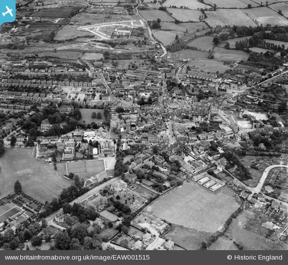
EAW001515 ENGLAND (1946). The town centre, Braintree, 1946
© Copyright OpenStreetMap contributors and licensed by the OpenStreetMap Foundation. 2026. Cartography is licensed as CC BY-SA.
Nearby Images (8)
EAW001515

EAW001516

EAW001517

EAW043695

EPW001743

EAW043697

EAW043698

EPW001744

Details
| Title | [EAW001515] The town centre, Braintree, 1946 |
| Reference | EAW001515 |
| Date | 5-July-1946 |
| Link | |
| Place name | BRAINTREE |
| Parish | |
| District | |
| Country | ENGLAND |
| Easting / Northing | 575742, 223153 |
| Longitude / Latitude | 0.55350541887401, 51.87876764064 |
| National Grid Reference | TL757232 |
Pins

Stephen Mirrington |
Wednesday 8th of October 2025 03:28:12 PM | |
|
Stephen Mirrington |
Wednesday 8th of October 2025 03:27:14 PM | |

Matt Aldred edob.mattaldred.com |
Sunday 2nd of March 2025 03:00:49 PM | |
|
Matt Aldred edob.mattaldred.com |
Sunday 2nd of March 2025 03:00:34 PM | |
|
Matt Aldred edob.mattaldred.com |
Sunday 2nd of March 2025 03:00:07 PM | |
|
Paul S |
Wednesday 20th of July 2022 06:44:40 PM | |
|
David Smith |
Tuesday 26th of October 2021 10:12:13 PM | |
|
Karen |
Saturday 27th of June 2020 10:59:37 PM | |
|
shadysheepie |
Thursday 27th of February 2020 04:44:52 PM | |
|
shadysheepie |
Thursday 27th of February 2020 04:43:36 PM | |

Sparky |
Saturday 23rd of September 2017 01:57:21 PM | |
|
Sparky |
Saturday 23rd of September 2017 01:56:28 PM | |
|
Sparky |
Saturday 23rd of September 2017 01:56:10 PM | |
|
Sparky |
Saturday 23rd of September 2017 01:55:20 PM | |
|
Sparky |
Saturday 23rd of September 2017 01:54:34 PM |