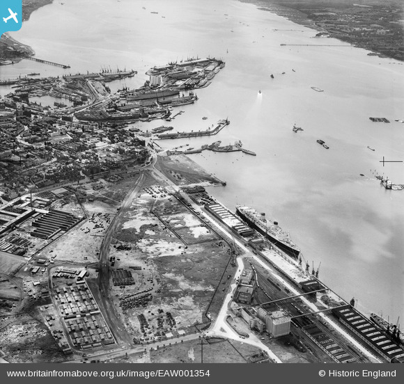
EAW001354 ENGLAND (1946). The Docks, Southampton, 1946
© Copyright OpenStreetMap contributors and licensed by the OpenStreetMap Foundation. 2026. Cartography is licensed as CC BY-SA.
Nearby Images (10)
Details
| Title | [EAW001354] The Docks, Southampton, 1946 |
| Reference | EAW001354 |
| Date | 28-June-1946 |
| Link | |
| Place name | SOUTHAMPTON |
| Parish | |
| District | |
| Country | ENGLAND |
| Easting / Northing | 441532, 111145 |
| Longitude / Latitude | -1.4093582927552, 50.897735033433 |
| National Grid Reference | SU415111 |
Pins

Jessie Russel |
Monday 7th of July 2025 11:08:08 PM | |

Jessie Russel |
Monday 7th of July 2025 11:07:07 PM | |

redmist |
Tuesday 6th of December 2022 10:34:51 PM | |

redmist |
Tuesday 6th of December 2022 10:34:11 PM | |

redmist |
Tuesday 6th of December 2022 10:33:43 PM | |

john g |
Saturday 25th of October 2014 10:47:46 AM | |

Class31 |
Saturday 31st of May 2014 06:53:28 AM | |

Class31 |
Saturday 31st of May 2014 06:51:53 AM | |

Class31 |
Saturday 31st of May 2014 06:49:47 AM | |

Class31 |
Saturday 31st of May 2014 06:45:13 AM | |

Class31 |
Saturday 31st of May 2014 06:41:57 AM | |

Class31 |
Saturday 31st of May 2014 06:38:19 AM | |

Class31 |
Saturday 31st of May 2014 06:37:14 AM | |

Class31 |
Saturday 31st of May 2014 06:35:54 AM | |

Class31 |
Friday 30th of May 2014 08:44:23 PM |


![[EAW001354] The Docks, Southampton, 1946](http://britainfromabove.org.uk/sites/all/libraries/aerofilms-images/public/100x100/EAW/001/EAW001354.jpg)
![[EAW001359] The Docks, Southampton, 1946](http://britainfromabove.org.uk/sites/all/libraries/aerofilms-images/public/100x100/EAW/001/EAW001359.jpg)
![[EAW001357] RMS Queen Elizabeth at the New Docks (Western Docks) looking towards Southampton Water, Southampton, from the north, 1946](http://britainfromabove.org.uk/sites/all/libraries/aerofilms-images/public/100x100/EAW/001/EAW001357.jpg)
![[EAW001353] RMS Queen Elizabeth at the New Docks (Western Docks), Southampton, from the north-west, 1946](http://britainfromabove.org.uk/sites/all/libraries/aerofilms-images/public/100x100/EAW/001/EAW001353.jpg)
![[EAW051599] An unidentified Ocean Liner docked alongside No 101 Passenger & Goods Shed, Southampton, from the south, 1953](http://britainfromabove.org.uk/sites/all/libraries/aerofilms-images/public/100x100/EAW/051/EAW051599.jpg)
![[EPW041063] Reclamation of the Western Docks between Royal Pier and Millbrook, Southampton, from the south-east, 1933](http://britainfromabove.org.uk/sites/all/libraries/aerofilms-images/public/100x100/EPW/041/EPW041063.jpg)
![[EAW022290] A Union-Castle Line ship at the New Docks (Western Docks), Southampton, from the south, 1949](http://britainfromabove.org.uk/sites/all/libraries/aerofilms-images/public/100x100/EAW/022/EAW022290.jpg)
![[EAW035610] The Festival of Britain Exhibition Ship (HMS Campania) moored alongside the Passenger and Goods Shed No 101, Southampton, 1951](http://britainfromabove.org.uk/sites/all/libraries/aerofilms-images/public/100x100/EAW/035/EAW035610.jpg)
![[EPW009072] The Town Quay and Royal Pier, Southampton, 1923](http://britainfromabove.org.uk/sites/all/libraries/aerofilms-images/public/100x100/EPW/009/EPW009072.jpg)
![[EAW035611] The Festival of Britain Exhibition Ship (HMS Campania) moored alongside the Passenger and Goods Shed No 101, Southampton, 1951](http://britainfromabove.org.uk/sites/all/libraries/aerofilms-images/public/100x100/EAW/035/EAW035611.jpg)