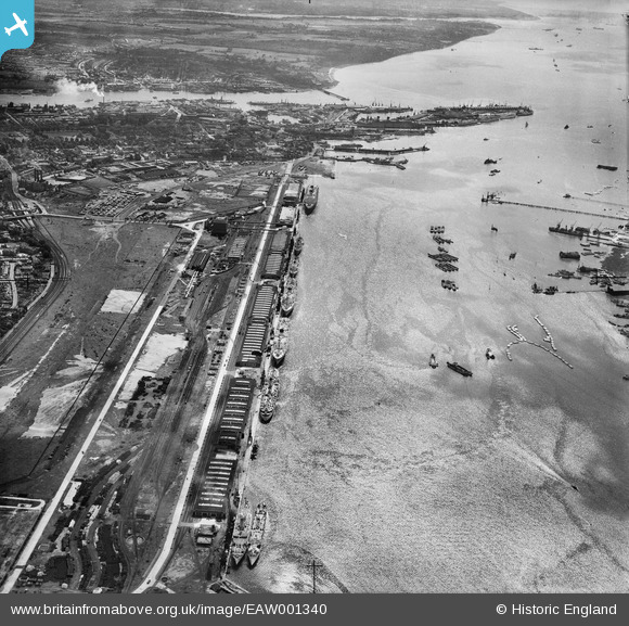
EAW001340 ENGLAND (1946). The New Docks (Western Docks), Southampton, from the north-west, 1946
© Copyright OpenStreetMap contributors and licensed by the OpenStreetMap Foundation. 2026. Cartography is licensed as CC BY-SA.
Nearby Images (6)
Details
| Title | [EAW001340] The New Docks (Western Docks), Southampton, from the north-west, 1946 |
| Reference | EAW001340 |
| Date | 28-June-1946 |
| Link | |
| Place name | SOUTHAMPTON |
| Parish | |
| District | |
| Country | ENGLAND |
| Easting / Northing | 440036, 111872 |
| Longitude / Latitude | -1.4305525670003, 50.904378623099 |
| National Grid Reference | SU400119 |
Pins

Matt Aldred edob.mattaldred.com |
Sunday 20th of July 2025 10:51:47 AM | |

Matt Aldred edob.mattaldred.com |
Sunday 20th of July 2025 10:51:37 AM | |

Jessie Russel |
Monday 7th of July 2025 10:18:58 PM | |

Jessie Russel |
Monday 7th of July 2025 10:16:18 PM | |

redmist |
Monday 5th of December 2022 09:10:38 PM | |

redmist |
Monday 5th of December 2022 09:08:58 PM | |

redmist |
Monday 5th of December 2022 09:08:29 PM | |

redmist |
Monday 5th of December 2022 09:07:26 PM | |

redmist |
Monday 5th of December 2022 09:06:46 PM | |

redmist |
Monday 5th of December 2022 09:06:17 PM | |

redmist |
Monday 5th of December 2022 08:55:40 PM | |

redmist |
Monday 5th of December 2022 08:54:16 PM | |

Graham Yaxley |
Monday 5th of January 2015 12:07:19 AM | |

Class31 |
Saturday 31st of May 2014 07:24:06 AM |


![[EAW001340] The New Docks (Western Docks), Southampton, from the north-west, 1946](http://britainfromabove.org.uk/sites/all/libraries/aerofilms-images/public/100x100/EAW/001/EAW001340.jpg)
![[EAW051590] SS America docked in the Cruise Liner Terminal, Southampton, from the south, 1953](http://britainfromabove.org.uk/sites/all/libraries/aerofilms-images/public/100x100/EAW/051/EAW051590.jpg)
![[EAW001341] The New Docks (Western Docks), Southampton, from the north-west, 1946](http://britainfromabove.org.uk/sites/all/libraries/aerofilms-images/public/100x100/EAW/001/EAW001341.jpg)
![[EAW051591] SS America docked in the Cruise Liner Terminal, Southampton, from the south, 1953](http://britainfromabove.org.uk/sites/all/libraries/aerofilms-images/public/100x100/EAW/051/EAW051591.jpg)
![[EAW022294] RMS Mauretania at the New Docks (Western Docks), Southampton, 1949](http://britainfromabove.org.uk/sites/all/libraries/aerofilms-images/public/100x100/EAW/022/EAW022294.jpg)
![[EAW051592] RMS Caronia docked in the Cruise Liner Terminal, Southampton, from the south, 1953](http://britainfromabove.org.uk/sites/all/libraries/aerofilms-images/public/100x100/EAW/051/EAW051592.jpg)