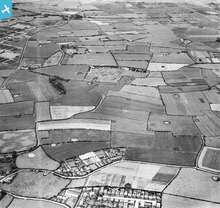
EAW001284 ENGLAND (1946). The Garden Hey Road Nursery and the surrounding countryside, Hoylake, 1946

© Copyright OpenStreetMap contributors and licensed by the OpenStreetMap Foundation. 2026. Cartography is licensed as CC BY-SA.
Details
| Title | [EAW001284] The Garden Hey Road Nursery and the surrounding countryside, Hoylake, 1946 |
| Reference | EAW001284 |
| Date | 24-June-1946 |
| Link | |
| Place name | HOYLAKE |
| Parish | |
| District | |
| Country | ENGLAND |
| Easting / Northing | 324694, 388781 |
| Longitude / Latitude | -3.1324879923119, 53.39022750089 |
| National Grid Reference | SJ247888 |
Pins

cptpies |
Monday 6th of January 2014 11:01:17 AM | |
|
spuddle |
Monday 4th of November 2013 02:38:39 PM | |
|
spuddle |
Monday 4th of November 2013 02:33:58 PM | |
|
spuddle |
Monday 4th of November 2013 02:33:26 PM | |
|
spuddle |
Monday 4th of November 2013 02:32:07 PM | |
|
spuddle |
Monday 4th of November 2013 02:31:12 PM | |
|
spuddle |
Monday 4th of November 2013 02:20:51 PM |