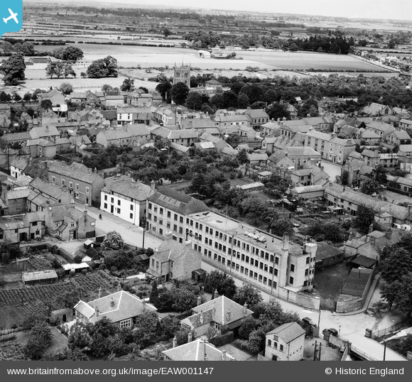
EAW001147 ENGLAND (1946). Eatoughs Boot Factory on Brook Street and environs, Syston, 1946
© Copyright OpenStreetMap contributors and licensed by the OpenStreetMap Foundation. 2026. Cartography is licensed as CC BY-SA.
Nearby Images (7)
Details
| Title | [EAW001147] Eatoughs Boot Factory on Brook Street and environs, Syston, 1946 |
| Reference | EAW001147 |
| Date | 20-June-1946 |
| Link | |
| Place name | SYSTON |
| Parish | SYSTON |
| District | |
| Country | ENGLAND |
| Easting / Northing | 462459, 311735 |
| Longitude / Latitude | -1.0756175543944, 52.69934022248 |
| National Grid Reference | SK625117 |
Pins
Be the first to add a comment to this image!


![[EAW001147] Eatoughs Boot Factory on Brook Street and environs, Syston, 1946](http://britainfromabove.org.uk/sites/all/libraries/aerofilms-images/public/100x100/EAW/001/EAW001147.jpg)
![[EAW001146] Eatoughs Boot Factory on Brook Street and environs, Syston, 1946](http://britainfromabove.org.uk/sites/all/libraries/aerofilms-images/public/100x100/EAW/001/EAW001146.jpg)
![[EAW001149] Eatoughs Boot Factory on Brook Street and environs, Syston, 1946](http://britainfromabove.org.uk/sites/all/libraries/aerofilms-images/public/100x100/EAW/001/EAW001149.jpg)
![[EAW001145] Eatoughs Boot Factory on Brook Street and environs, Syston, 1946](http://britainfromabove.org.uk/sites/all/libraries/aerofilms-images/public/100x100/EAW/001/EAW001145.jpg)
![[EAW001148] Eatoughs Boot Factory on Brook Street and environs, Syston, 1946](http://britainfromabove.org.uk/sites/all/libraries/aerofilms-images/public/100x100/EAW/001/EAW001148.jpg)
![[EAW001144] Eatoughs Boot Factory on Brook Street and environs, Syston, 1946](http://britainfromabove.org.uk/sites/all/libraries/aerofilms-images/public/100x100/EAW/001/EAW001144.jpg)
![[EAW001150] Eatoughs Boot Factory on Brook Street and environs, Syston, 1946](http://britainfromabove.org.uk/sites/all/libraries/aerofilms-images/public/100x100/EAW/001/EAW001150.jpg)