
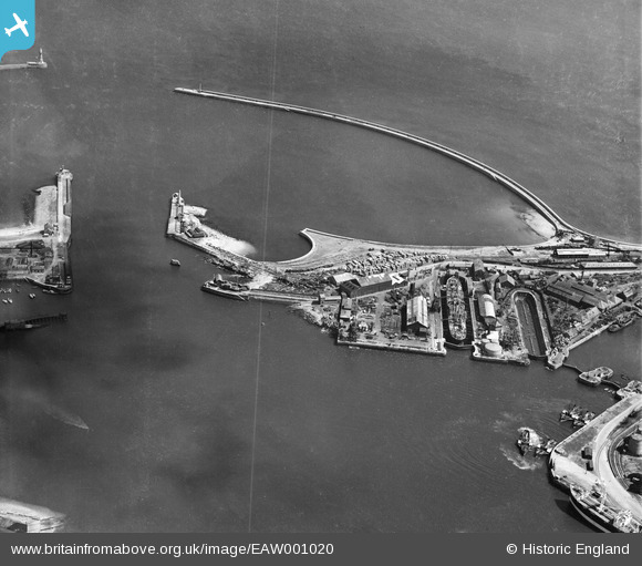
EAW001020 ENGLAND (1946). The Sunderland Harbour Entrance, the North Tidal Basin and New South Pier, Sunderland, 1946
© Copyright OpenStreetMap contributors and licensed by the OpenStreetMap Foundation. 2026. Cartography is licensed as CC BY-SA.
Nearby Images (3)
EAW001020

EAW001022

EPW020538

Details
| Title | [EAW001020] The Sunderland Harbour Entrance, the North Tidal Basin and New South Pier, Sunderland, 1946 |
| Reference | EAW001020 |
| Date | 6-June-1946 |
| Link | |
| Place name | SUNDERLAND |
| Parish | |
| District | |
| Country | ENGLAND |
| Easting / Northing | 441019, 558077 |
| Longitude / Latitude | -1.3600385290123, 54.915626727886 |
| National Grid Reference | NZ410581 |
Pins

Matt Aldred edob.mattaldred.com |
Monday 23rd of November 2020 08:38:52 PM | |
|
Matt Aldred edob.mattaldred.com |
Monday 23rd of November 2020 08:36:00 PM | |
|
Matt Aldred edob.mattaldred.com |
Monday 23rd of November 2020 08:35:12 PM | |

redmist |
Thursday 24th of September 2020 08:07:15 PM | |
|
redmist |
Thursday 24th of September 2020 08:05:04 PM | |
|
redmist |
Saturday 26th of October 2019 03:26:06 PM | |
|
redmist |
Saturday 26th of October 2019 03:24:32 PM | |
|
redmist |
Sunday 17th of March 2019 09:55:42 PM | |
|
Chris Kolonko |
Friday 15th of September 2017 09:56:19 PM | |
|
Chris Kolonko |
Friday 15th of September 2017 09:55:35 PM | |
|
Chris Kolonko |
Friday 15th of September 2017 09:55:00 PM | |
|
Chris Kolonko |
Friday 15th of September 2017 09:54:36 PM | |
|
Chris Kolonko |
Friday 15th of September 2017 09:54:13 PM | |
|
Pitman 105 |
Friday 28th of October 2016 11:29:51 AM | |
|
Coops |
Friday 11th of March 2016 04:45:26 PM | |
|
Coops |
Friday 11th of March 2016 04:44:15 PM | |
|
Coops |
Friday 11th of March 2016 04:43:28 PM | |
|
Coops |
Friday 11th of March 2016 04:39:57 PM | |
|
Coops |
Friday 11th of March 2016 04:38:52 PM |