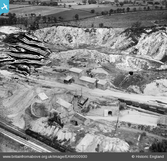
EAW000930 ENGLAND (1946). The Cloud Hill Limestone Quarry, Breedon on the Hill, 1946. This image has been produced from a damaged negative.
© Copyright OpenStreetMap contributors and licensed by the OpenStreetMap Foundation. 2026. Cartography is licensed as CC BY-SA.
Nearby Images (17)
Details
| Title | [EAW000930] The Cloud Hill Limestone Quarry, Breedon on the Hill, 1946. This image has been produced from a damaged negative. |
| Reference | EAW000930 |
| Date | 29-May-1946 |
| Link | |
| Place name | BREEDON ON THE HILL |
| Parish | BREEDON ON THE HILL |
| District | |
| Country | ENGLAND |
| Easting / Northing | 441081, 321482 |
| Longitude / Latitude | -1.3907629098497, 52.789011227713 |
| National Grid Reference | SK411215 |
Pins
Be the first to add a comment to this image!


![[EAW000930] The Cloud Hill Limestone Quarry, Breedon on the Hill, 1946. This image has been produced from a damaged negative.](http://britainfromabove.org.uk/sites/all/libraries/aerofilms-images/public/100x100/EAW/000/EAW000930.jpg)
![[EPW062109] Cloud Hill Lime Works and environs, Breedon on the Hill, 1939](http://britainfromabove.org.uk/sites/all/libraries/aerofilms-images/public/100x100/EPW/062/EPW062109.jpg)
![[EAW000938] The Cloud Hill Limestone Quarry, Breedon on the Hill, 1946](http://britainfromabove.org.uk/sites/all/libraries/aerofilms-images/public/100x100/EAW/000/EAW000938.jpg)
![[EPW062110] Cloud Hill Lime Works, Breedon on the Hill, 1939](http://britainfromabove.org.uk/sites/all/libraries/aerofilms-images/public/100x100/EPW/062/EPW062110.jpg)
![[EAW000932] The Cloud Hill Limestone Quarry, Breedon on the Hill, from the south, 1946. This image has been produced from a damaged negative.](http://britainfromabove.org.uk/sites/all/libraries/aerofilms-images/public/100x100/EAW/000/EAW000932.jpg)
![[EAW000939] The Cloud Hill Limestone Quarry, Breedon on the Hill, 1946](http://britainfromabove.org.uk/sites/all/libraries/aerofilms-images/public/100x100/EAW/000/EAW000939.jpg)
![[EPW062112] Cloud Hill Lime Works, Breedon on the Hill, 1939](http://britainfromabove.org.uk/sites/all/libraries/aerofilms-images/public/100x100/EPW/062/EPW062112.jpg)
![[EAW000927] The Cloud Hill Limestone Quarry, Breedon on the Hill, 1946. This image has been produced from a print.](http://britainfromabove.org.uk/sites/all/libraries/aerofilms-images/public/100x100/EAW/000/EAW000927.jpg)
![[EAW000928] The Cloud Hill Limestone Quarry, Breedon on the Hill, from the south-west, 1946. This image has been produced from a print.](http://britainfromabove.org.uk/sites/all/libraries/aerofilms-images/public/100x100/EAW/000/EAW000928.jpg)
![[EAW000936] The Cloud Hill Limestone Quarry, Breedon on the Hill, 1946](http://britainfromabove.org.uk/sites/all/libraries/aerofilms-images/public/100x100/EAW/000/EAW000936.jpg)
![[EAW000931] The Cloud Hill Limestone Quarry, Breedon on the Hill, 1946. This image has been produced from a print.](http://britainfromabove.org.uk/sites/all/libraries/aerofilms-images/public/100x100/EAW/000/EAW000931.jpg)
![[EPW062114] Cloud Hill Lime Works and environs, Breedon on the Hill, 1939](http://britainfromabove.org.uk/sites/all/libraries/aerofilms-images/public/100x100/EPW/062/EPW062114.jpg)
![[EPW062115] Cloud Hill Lime Works, Breedon on the Hill, 1939](http://britainfromabove.org.uk/sites/all/libraries/aerofilms-images/public/100x100/EPW/062/EPW062115.jpg)
![[EPW062117] Cloud Hill Lime Works and environs, Breedon on the Hill, 1939](http://britainfromabove.org.uk/sites/all/libraries/aerofilms-images/public/100x100/EPW/062/EPW062117.jpg)
![[EPW062113] Cloud Hill Lime Works and environs, Breedon on the Hill, 1939](http://britainfromabove.org.uk/sites/all/libraries/aerofilms-images/public/100x100/EPW/062/EPW062113.jpg)
![[EAW000934] The Cloud Hill Limestone Quarry, Breedon on the Hill, from the north-west, 1946](http://britainfromabove.org.uk/sites/all/libraries/aerofilms-images/public/100x100/EAW/000/EAW000934.jpg)
![[EAW000933] The Cloud Hill Limestone Quarry, Breedon on the Hill, from the west, 1946](http://britainfromabove.org.uk/sites/all/libraries/aerofilms-images/public/100x100/EAW/000/EAW000933.jpg)