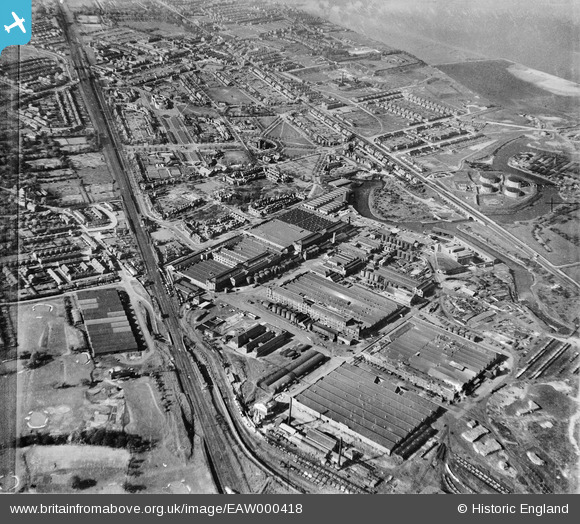
EAW000418 ENGLAND (1946). The Unilever Sunlight Soap Works and Port Sunlight, Bromborough, 1946
© Copyright OpenStreetMap contributors and licensed by the OpenStreetMap Foundation. 2026. Cartography is licensed as CC BY-SA.
Details
| Title | [EAW000418] The Unilever Sunlight Soap Works and Port Sunlight, Bromborough, 1946 |
| Reference | EAW000418 |
| Date | 18-April-1946 |
| Link | |
| Place name | BROMBOROUGH |
| Parish | |
| District | |
| Country | ENGLAND |
| Easting / Northing | 333901, 383993 |
| Longitude / Latitude | -2.9930516578575, 53.348424378069 |
| National Grid Reference | SJ339840 |
Pins

Matt Aldred edob.mattaldred.com |
Friday 26th of February 2021 06:03:03 PM | |

redmist |
Thursday 31st of December 2020 05:17:58 PM | |

redmist |
Thursday 31st of December 2020 05:14:17 PM | |

redmist |
Thursday 31st of December 2020 05:13:25 PM | |

redmist |
Thursday 31st of December 2020 04:53:52 PM | |

redmist |
Sunday 13th of October 2019 05:18:54 PM | |

redmist |
Sunday 13th of October 2019 05:16:10 PM | |

redmist |
Sunday 13th of October 2019 05:15:14 PM | |

Sparky |
Monday 6th of November 2017 09:59:45 PM | |

beast66606 |
Thursday 19th of June 2014 10:55:30 AM | |

Debs. |
Tuesday 29th of April 2014 08:19:28 PM | |

bri445 |
Sunday 26th of January 2014 11:44:41 AM | |

bri445 |
Sunday 26th of January 2014 11:43:56 AM |


![[EAW000418] The Unilever Sunlight Soap Works and Port Sunlight, Bromborough, 1946](http://britainfromabove.org.uk/sites/all/libraries/aerofilms-images/public/100x100/EAW/000/EAW000418.jpg)
![[EPW044477] The Lever Brothers Sunlight Soap Works, the Auditorium and housing at Park Road, Port Sunlight, 1934](http://britainfromabove.org.uk/sites/all/libraries/aerofilms-images/public/100x100/EPW/044/EPW044477.jpg)
![[EPW044478] The Lever Brothers Sunlight Soap Works and housing at Park Road, Port Sunlight, 1934](http://britainfromabove.org.uk/sites/all/libraries/aerofilms-images/public/100x100/EPW/044/EPW044478.jpg)
![[EPW044476] The Lever Brothers Sunlight Soap Works and housing at Park Road, Port Sunlight, 1934](http://britainfromabove.org.uk/sites/all/libraries/aerofilms-images/public/100x100/EPW/044/EPW044476.jpg)
