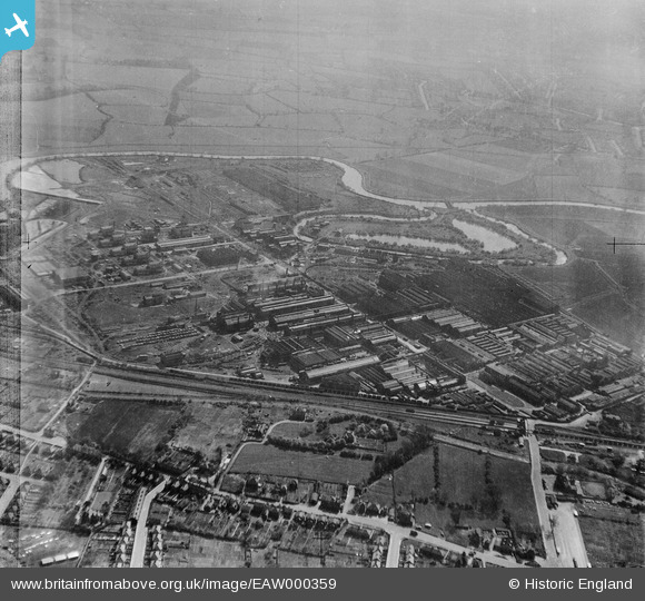
EAW000359 ENGLAND (1946). Courtaulds Silk Factory and environs, Spondon, 1946
© Copyright OpenStreetMap contributors and licensed by the OpenStreetMap Foundation. 2026. Cartography is licensed as CC BY-SA.
Nearby Images (27)
Details
| Title | [EAW000359] Courtaulds Silk Factory and environs, Spondon, 1946 |
| Reference | EAW000359 |
| Date | 16-April-1946 |
| Link | |
| Place name | SPONDON |
| Parish | |
| District | |
| Country | ENGLAND |
| Easting / Northing | 439860, 334634 |
| Longitude / Latitude | -1.4072612177942, 52.907338858986 |
| National Grid Reference | SK399346 |
Pins

Chaddite |
Monday 17th of January 2022 04:16:56 PM | |

Triggy |
Tuesday 22nd of September 2015 09:00:17 PM | |

Triggy |
Tuesday 22nd of September 2015 08:57:17 PM | |

Triggy |
Monday 10th of February 2014 07:47:57 PM | |

Triggy |
Monday 10th of February 2014 07:46:12 PM | |

Triggy |
Friday 17th of January 2014 01:06:59 PM | |

Peter Kazmierczak |
Friday 13th of September 2013 11:41:08 PM |


![[EAW000359] Courtaulds Silk Factory and environs, Spondon, 1946](http://britainfromabove.org.uk/sites/all/libraries/aerofilms-images/public/100x100/EAW/000/EAW000359.jpg)
![[EAW000361] Courtaulds Silk Factory and environs, Spondon, 1946](http://britainfromabove.org.uk/sites/all/libraries/aerofilms-images/public/100x100/EAW/000/EAW000361.jpg)
![[EAW000362] Courtaulds Silk Factory and environs, Spondon, 1946](http://britainfromabove.org.uk/sites/all/libraries/aerofilms-images/public/100x100/EAW/000/EAW000362.jpg)
![[EAW000363] Courtaulds Silk Factory and environs, Spondon, 1946](http://britainfromabove.org.uk/sites/all/libraries/aerofilms-images/public/100x100/EAW/000/EAW000363.jpg)
![[EAW000367] Courtaulds Silk Factory and environs, Spondon, 1946](http://britainfromabove.org.uk/sites/all/libraries/aerofilms-images/public/100x100/EAW/000/EAW000367.jpg)
![[EAW000366] Courtaulds Silk Factory and environs, Spondon, 1946](http://britainfromabove.org.uk/sites/all/libraries/aerofilms-images/public/100x100/EAW/000/EAW000366.jpg)
![[EPW018035] The British Celanese synthetic fibres works, Spondon, 1927](http://britainfromabove.org.uk/sites/all/libraries/aerofilms-images/public/100x100/EPW/018/EPW018035.jpg)
![[EAW000920] The British Celanese synthetic fibres works, Spondon, from the south-east, 1946](http://britainfromabove.org.uk/sites/all/libraries/aerofilms-images/public/100x100/EAW/000/EAW000920.jpg)
![[EAW000364] Courtaulds Silk Factory and environs, Spondon, 1946](http://britainfromabove.org.uk/sites/all/libraries/aerofilms-images/public/100x100/EAW/000/EAW000364.jpg)
![[EAW000914] The British Celanese synthetic fibres works, Spondon, from the east, 1946](http://britainfromabove.org.uk/sites/all/libraries/aerofilms-images/public/100x100/EAW/000/EAW000914.jpg)
![[EAW000921] The British Celanese synthetic fibres works, Spondon, from the south, 1946](http://britainfromabove.org.uk/sites/all/libraries/aerofilms-images/public/100x100/EAW/000/EAW000921.jpg)
![[EAW000356] Courtaulds Silk Factory and environs, Spondon, 1946](http://britainfromabove.org.uk/sites/all/libraries/aerofilms-images/public/100x100/EAW/000/EAW000356.jpg)
![[EAW002822] The British Celanese Synthetic Fibres Works, Spondon, 1946](http://britainfromabove.org.uk/sites/all/libraries/aerofilms-images/public/100x100/EAW/002/EAW002822.jpg)
![[EAW000357] Courtaulds Silk Factory and environs, Spondon, 1946](http://britainfromabove.org.uk/sites/all/libraries/aerofilms-images/public/100x100/EAW/000/EAW000357.jpg)
![[EAW002819] The British Celanese Synthetic Fibres Works and the River Derwent, Spondon, 1946](http://britainfromabove.org.uk/sites/all/libraries/aerofilms-images/public/100x100/EAW/002/EAW002819.jpg)
![[EAW000358] Courtaulds Silk Factory and environs, Spondon, 1946](http://britainfromabove.org.uk/sites/all/libraries/aerofilms-images/public/100x100/EAW/000/EAW000358.jpg)
![[EAW002818] The British Celanese Synthetic Fibres Works, Spondon, 1946](http://britainfromabove.org.uk/sites/all/libraries/aerofilms-images/public/100x100/EAW/002/EAW002818.jpg)
![[EPW018038] The British Celanese synthetic fibres works, Spondon, 1927](http://britainfromabove.org.uk/sites/all/libraries/aerofilms-images/public/100x100/EPW/018/EPW018038.jpg)
![[EAW000919] The British Celanese synthetic fibres works, Spondon, from the south-west, 1946](http://britainfromabove.org.uk/sites/all/libraries/aerofilms-images/public/100x100/EAW/000/EAW000919.jpg)
![[EPW018039] The British Celanese synthetic fibres works, Spondon, 1927](http://britainfromabove.org.uk/sites/all/libraries/aerofilms-images/public/100x100/EPW/018/EPW018039.jpg)
![[EAW000913] The British Celanese synthetic fibres works, Spondon, from the south-east, 1946](http://britainfromabove.org.uk/sites/all/libraries/aerofilms-images/public/100x100/EAW/000/EAW000913.jpg)
![[EAW000365] Courtaulds Silk Factory and environs, Spondon, 1946](http://britainfromabove.org.uk/sites/all/libraries/aerofilms-images/public/100x100/EAW/000/EAW000365.jpg)
![[EAW000360] Courtaulds Silk Factory and environs, Spondon, 1946](http://britainfromabove.org.uk/sites/all/libraries/aerofilms-images/public/100x100/EAW/000/EAW000360.jpg)
![[EAW000917] The British Celanese synthetic fibres works, Spondon, from the south-east, 1946](http://britainfromabove.org.uk/sites/all/libraries/aerofilms-images/public/100x100/EAW/000/EAW000917.jpg)
![[EAW000923] The British Celanese synthetic fibres works, Spondon, 1946. This image has been produced from a print.](http://britainfromabove.org.uk/sites/all/libraries/aerofilms-images/public/100x100/EAW/000/EAW000923.jpg)
![[EPW018037] The British Celanese synthetic fibres works, Spondon, 1927](http://britainfromabove.org.uk/sites/all/libraries/aerofilms-images/public/100x100/EPW/018/EPW018037.jpg)
![[EAW000915] The British Celanese synthetic fibres works, Spondon, from the south, 1946](http://britainfromabove.org.uk/sites/all/libraries/aerofilms-images/public/100x100/EAW/000/EAW000915.jpg)