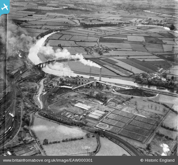
EAW000301 ENGLAND (1946). Willow Holme Power Station, the Carlisle Corporation Sewage Disposal Works and environs, Willow Holme, 1946
© Copyright OpenStreetMap contributors and licensed by the OpenStreetMap Foundation. 2026. Cartography is licensed as CC BY-SA.
Nearby Images (6)
Details
| Title | [EAW000301] Willow Holme Power Station, the Carlisle Corporation Sewage Disposal Works and environs, Willow Holme, 1946 |
| Reference | EAW000301 |
| Date | 26-April-1946 |
| Link | |
| Place name | WILLOW HOLME |
| Parish | |
| District | |
| Country | ENGLAND |
| Easting / Northing | 338559, 556675 |
| Longitude / Latitude | -2.958236378538, 54.900933205127 |
| National Grid Reference | NY386567 |
Pins

AnonEuMouse |
Wednesday 22nd of June 2022 10:24:30 AM |


![[EAW000301] Willow Holme Power Station, the Carlisle Corporation Sewage Disposal Works and environs, Willow Holme, 1946](http://britainfromabove.org.uk/sites/all/libraries/aerofilms-images/public/100x100/EAW/000/EAW000301.jpg)
![[EAW000300] Willow Holme Power Station, the Carlisle Corporation Sewage Disposal Works and environs, Willow Holme, 1946](http://britainfromabove.org.uk/sites/all/libraries/aerofilms-images/public/100x100/EAW/000/EAW000300.jpg)
![[EAW000304] Willow Holme Power Station, the Carlisle Corporation Sewage Disposal Works and environs, Willow Holme, 1946](http://britainfromabove.org.uk/sites/all/libraries/aerofilms-images/public/100x100/EAW/000/EAW000304.jpg)
![[EPW040211] Willowholme Power Station, Willow Holme, 1932](http://britainfromabove.org.uk/sites/all/libraries/aerofilms-images/public/100x100/EPW/040/EPW040211.jpg)
![[EAW000302] Willow Holme Power Station, the Carlisle Corporation Sewage Disposal Works and environs, Willow Holme, 1946](http://britainfromabove.org.uk/sites/all/libraries/aerofilms-images/public/100x100/EAW/000/EAW000302.jpg)
![[EAW000303] Willow Holme Power Station, the Carlisle Corporation Sewage Disposal Works and environs, Willow Holme, 1946](http://britainfromabove.org.uk/sites/all/libraries/aerofilms-images/public/100x100/EAW/000/EAW000303.jpg)
