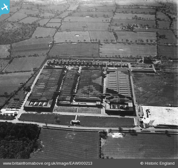
EAW000213 ENGLAND (1946). The Standard Motor Company shadow factory, Tile Hill, 1946
© Copyright OpenStreetMap contributors and licensed by the OpenStreetMap Foundation. 2026. Cartography is licensed as CC BY-SA.
Nearby Images (10)
Details
| Title | [EAW000213] The Standard Motor Company shadow factory, Tile Hill, 1946 |
| Reference | EAW000213 |
| Date | 15-April-1946 |
| Link | |
| Place name | TILE HILL |
| Parish | |
| District | |
| Country | ENGLAND |
| Easting / Northing | 427307, 279299 |
| Longitude / Latitude | -1.5985087972876, 52.410633558537 |
| National Grid Reference | SP273793 |
Pins

Matt Aldred edob.mattaldred.com |
Sunday 2nd of March 2025 11:49:32 AM | |

Matt Aldred edob.mattaldred.com |
Sunday 2nd of March 2025 11:49:17 AM | |

Matt Aldred edob.mattaldred.com |
Friday 26th of February 2021 03:52:56 PM | |

Sparky |
Friday 3rd of November 2017 09:32:51 PM | |

Sparky |
Friday 3rd of November 2017 09:32:31 PM | |

Sparky |
Friday 3rd of November 2017 09:32:07 PM | |

Sparky |
Friday 3rd of November 2017 09:31:27 PM | |

Sparky |
Friday 3rd of November 2017 09:30:39 PM | |

Sparky |
Friday 3rd of November 2017 09:29:53 PM | |

JerryE |
Sunday 20th of October 2013 05:47:41 PM | |
This was my thought too initially. But they are present on the 1905 OS map. |

Matt Aldred edob.mattaldred.com |
Friday 26th of February 2021 04:13:53 PM |


![[EAW000213] The Standard Motor Company shadow factory, Tile Hill, 1946](http://britainfromabove.org.uk/sites/all/libraries/aerofilms-images/public/100x100/EAW/000/EAW000213.jpg)
![[EAW000212] The Standard Motor Company shadow factory, Tile Hill, 1946](http://britainfromabove.org.uk/sites/all/libraries/aerofilms-images/public/100x100/EAW/000/EAW000212.jpg)
![[EAW000214] The Standard Motor Company shadow factory, Tile Hill, 1946](http://britainfromabove.org.uk/sites/all/libraries/aerofilms-images/public/100x100/EAW/000/EAW000214.jpg)
![[EAW000217] The Standard Motor Company shadow factory, Tile Hill, 1946](http://britainfromabove.org.uk/sites/all/libraries/aerofilms-images/public/100x100/EAW/000/EAW000217.jpg)
![[EAW000134] Standard Motor Co Banner Lane Works, Coventry, 1946](http://britainfromabove.org.uk/sites/all/libraries/aerofilms-images/public/100x100/EAW/000/EAW000134.jpg)
![[EAW000218] The Standard Motor Company shadow factory, Tile Hill, 1946](http://britainfromabove.org.uk/sites/all/libraries/aerofilms-images/public/100x100/EAW/000/EAW000218.jpg)
![[EAW000136] Standard Motor Co Banner Lane Works and environs, Coventry, 1946](http://britainfromabove.org.uk/sites/all/libraries/aerofilms-images/public/100x100/EAW/000/EAW000136.jpg)
![[EAW000216] The Standard Motor Company shadow factory, Tile Hill, 1946](http://britainfromabove.org.uk/sites/all/libraries/aerofilms-images/public/100x100/EAW/000/EAW000216.jpg)
![[EAW000215] The Standard Motor Company shadow factory, Tile Hill, 1946](http://britainfromabove.org.uk/sites/all/libraries/aerofilms-images/public/100x100/EAW/000/EAW000215.jpg)
![[EAW000133] Standard Motor Co Banner Lane Works, Coventry, 1946](http://britainfromabove.org.uk/sites/all/libraries/aerofilms-images/public/100x100/EAW/000/EAW000133.jpg)