
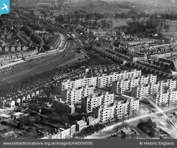
EAW000095 ENGLAND (1946). Flats at Herne Hill, Brixton, 1946
© Copyright OpenStreetMap contributors and licensed by the OpenStreetMap Foundation. 2026. Cartography is licensed as CC BY-SA.
Nearby Images (5)
EAW000095

EPW060447

EAW000096

EAW000098

EAW000097

Details
| Title | [EAW000095] Flats at Herne Hill, Brixton, 1946 |
| Reference | EAW000095 |
| Date | 1-April-1946 |
| Link | |
| Place name | BRIXTON |
| Parish | |
| District | |
| Country | ENGLAND |
| Easting / Northing | 531766, 174921 |
| Longitude / Latitude | -0.10321038543133, 51.457422972299 |
| National Grid Reference | TQ318749 |
Pins

Sparky |
Sunday 13th of August 2017 08:49:14 PM | |
I lived on this estate and these contained the pram sheds. I had always thought that they were there from when the estate was built in 1938 |

cal |
Monday 10th of June 2019 01:48:36 AM |
|
Leslie B |
Sunday 13th of March 2016 01:03:54 AM | |
|
fernando |
Wednesday 18th of November 2015 05:28:36 PM | |
|
fernando |
Wednesday 18th of November 2015 05:27:52 PM | |
|
John Wass |
Wednesday 29th of July 2015 09:33:17 PM | |
|
John Wass |
Wednesday 29th of July 2015 09:32:04 PM | |
|
John Wass |
Wednesday 29th of July 2015 09:31:13 PM | |
|
John Wass |
Wednesday 29th of July 2015 09:30:24 PM | |
|
John Wass |
Wednesday 29th of July 2015 09:29:13 PM | |
|
John Wass |
Wednesday 29th of July 2015 09:25:07 PM | |
|
John Wass |
Wednesday 29th of July 2015 09:24:09 PM | |
|
brianbeckett |
Thursday 11th of September 2014 05:05:50 PM |