
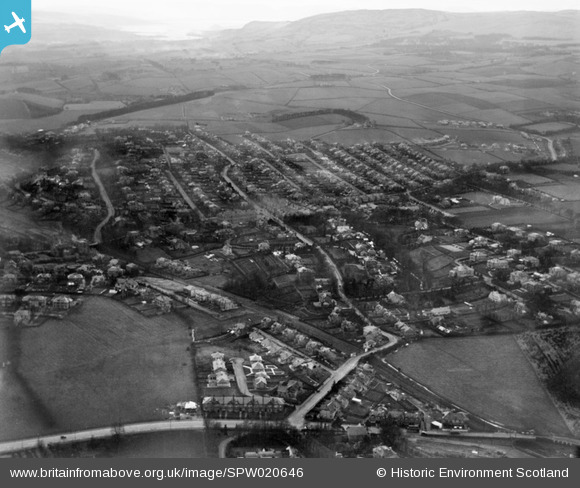
spw020646 SCOTLAND (1928). Bearsden. An oblique aerial photograph taken facing north.
© Copyright OpenStreetMap contributors and licensed by the OpenStreetMap Foundation. 2024. Cartography is licensed as CC BY-SA.
Nearby Images (3)
SPW020646

SAR024218

SAR024219

Details
| Title | [SPW020646] Bearsden. An oblique aerial photograph taken facing north. |
| Reference | SPW020646 |
| Date | 1928 |
| Link | Canmore Collection item 1256404 |
| Place name | |
| Parish | NEW KILPATRICK (BEARSDEN AND MILNGAVIE) |
| District | BEARSDEN AND MILNGAVIE |
| Country | SCOTLAND |
| Easting / Northing | 255118, 672122 |
| Longitude / Latitude | -4.3187200935445, 55.920362700308 |
| National Grid Reference | NS551721 |
Pins
 Lesley |
Tuesday 9th of February 2021 04:31:23 PM | |
John Wass |
Saturday 30th of May 2015 09:01:35 PM | |
Housewife69 |
Tuesday 14th of October 2014 02:41:47 PM | |
 Class31 |
Sunday 2nd of March 2014 07:21:53 PM | |
Class31 |
Sunday 2nd of March 2014 07:20:56 PM | |
Class31 |
Sunday 2nd of March 2014 07:20:20 PM | |
Brian Wilkinson |
Friday 31st of January 2014 03:37:02 PM | |
slowcoach |
Monday 2nd of July 2012 09:20:11 PM | |
slowcoach |
Monday 2nd of July 2012 09:06:29 PM | |
slowcoach |
Monday 2nd of July 2012 09:05:52 PM | |
mazman |
Wednesday 27th of June 2012 08:29:42 PM | |
mazman |
Wednesday 27th of June 2012 08:28:50 PM | |
mazman |
Wednesday 27th of June 2012 08:23:32 PM |
User Comment Contributions
View is closer to looking west than north. |
Class31 |
Sunday 2nd of March 2014 07:23:44 PM |
Dear all, That’s great; we’ve reviewed your comments and thanks to your help we can update the catalogue. Hope you have the same success solving some of our other mysteries! Brian Wilkinson Britain from Above Activity Officer (Scotland) |
Brian Wilkinson |
Thursday 19th of July 2012 12:07:51 PM |
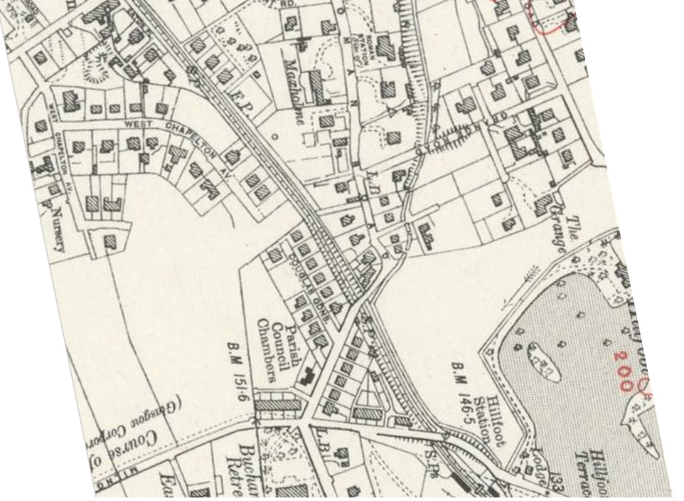 I agree with earlier comments. Bottom centre being junction of Boclair Road with Milngavie Road, Hillfoot, Bearsden. Across from Boclair Road is Roman Road. In the distance is the Firth of Clyde. I attach 1914 OS map, rotated to align with photo as best as poss. |
ewnmcg |
Monday 9th of July 2012 10:42:39 PM |