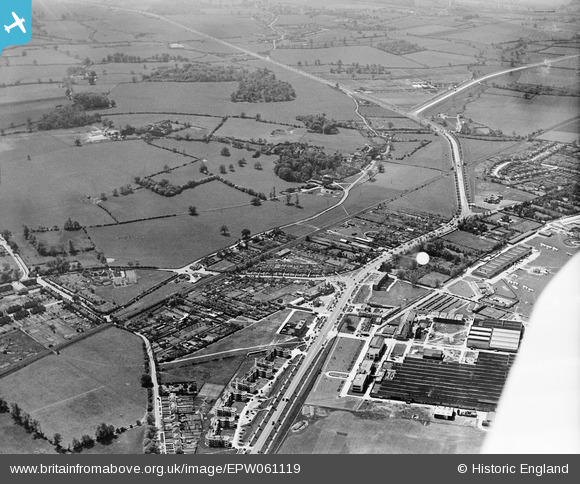
epw061119 ENGLAND (1939). St Albans Road, the Barnet By Pass and environs, Roe Green, 1939
© Copyright OpenStreetMap contributors and licensed by the OpenStreetMap Foundation. 2024. Cartography is licensed as CC BY-SA.
Details
| Title | [EPW061119] St Albans Road, the Barnet By Pass and environs, Roe Green, 1939 |
| Reference | EPW061119 |
| Date | 30-May-1939 |
| Link | |
| Place name | ROE GREEN |
| Parish | HATFIELD |
| District | |
| Country | ENGLAND |
| Easting / Northing | 521709, 208380 |
| Longitude / Latitude | -0.2362873217405, 51.760407938508 |
| National Grid Reference | TL217084 |
Pins
 Matt Aldred edob.mattaldred.com |
Thursday 7th of March 2024 02:35:32 PM | |
 Matt Aldred edob.mattaldred.com |
Wednesday 19th of April 2023 09:03:49 PM | |
 Paul |
Wednesday 8th of April 2020 12:39:18 PM | |
 jpm |
Thursday 28th of January 2016 12:13:23 PM | |
 Adrian Hepworth |
Monday 13th of October 2014 09:25:03 AM | |
 Adrian Hepworth |
Monday 13th of October 2014 09:20:35 AM | |
 Adrian Hepworth |
Monday 13th of October 2014 09:19:20 AM | |
 Adrian Hepworth |
Monday 13th of October 2014 09:17:45 AM | |
 Adrian Hepworth |
Monday 13th of October 2014 09:16:08 AM | |
 Adrian Hepworth |
Monday 13th of October 2014 08:31:09 AM | |
 Adrian Hepworth |
Monday 13th of October 2014 08:27:10 AM | |
 Adrian Hepworth |
Monday 13th of October 2014 08:25:23 AM | |
 Adrian Hepworth |
Monday 13th of October 2014 08:24:03 AM | |
 Adrian Hepworth |
Monday 13th of October 2014 08:22:59 AM | |
Katy Whitaker |
Tuesday 27th of August 2013 11:08:22 PM | |
Katy Whitaker |
Tuesday 27th of August 2013 11:03:18 PM |


![[EPW061119] St Albans Road, the Barnet By Pass and environs, Roe Green, 1939](http://britainfromabove.org.uk/sites/all/libraries/aerofilms-images/public/100x100/EPW/061/EPW061119.jpg)
![[EAW041970] Development of the Roe Green neighbourhood, Roe Green, 1952](http://britainfromabove.org.uk/sites/all/libraries/aerofilms-images/public/100x100/EAW/041/EAW041970.jpg)