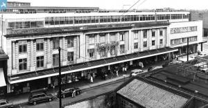
epw043397 ENGLAND (1933). The Pioneer Market, Ilford Railway Station and the town centre, Ilford, 1933
© Copyright OpenStreetMap contributors and licensed by the OpenStreetMap Foundation. 2025. Cartography is licensed as CC BY-SA.
Nearby Images (8)
Details
| Title | [EPW043397] The Pioneer Market, Ilford Railway Station and the town centre, Ilford, 1933 |
| Reference | EPW043397 |
| Date | October-1933 |
| Link | |
| Place name | ILFORD |
| Parish | |
| District | |
| Country | ENGLAND |
| Easting / Northing | 543610, 186328 |
| Longitude / Latitude | 0.071816985768876, 51.557052369015 |
| National Grid Reference | TQ436863 |
Pins
 pl8man |
Saturday 10th of February 2024 12:31:58 PM | |
 pl8man |
Saturday 10th of February 2024 12:22:33 PM | |
 pl8man |
Saturday 10th of February 2024 12:16:56 PM | |
 pl8man |
Saturday 10th of February 2024 12:14:43 PM | |
 pl8man |
Saturday 10th of February 2024 12:10:01 PM | |
 pl8man |
Saturday 10th of February 2024 12:06:32 PM | |
 pl8man |
Saturday 10th of February 2024 12:05:09 PM | |
 pl8man |
Saturday 10th of February 2024 11:53:23 AM | |
 pl8man |
Monday 25th of October 2021 12:34:21 PM | |
 Chelmerfella |
Tuesday 17th of December 2013 01:20:41 PM | |
 Chelmerfella |
Tuesday 17th of December 2013 01:15:25 PM | |
 Chelmerfella |
Tuesday 17th of December 2013 01:13:42 PM | |
 Chelmerfella |
Tuesday 17th of December 2013 01:12:03 PM | |
 Chelmerfella |
Tuesday 17th of December 2013 01:08:58 PM | |
 Chelmerfella |
Tuesday 17th of December 2013 01:07:21 PM | |
 Chelmerfella |
Tuesday 17th of December 2013 01:04:12 PM | |
 Chelmerfella |
Tuesday 17th of December 2013 01:02:55 PM | |
 Chelmerfella |
Tuesday 17th of December 2013 01:02:00 PM | |
 Chelmerfella |
Tuesday 17th of December 2013 01:00:49 PM | |
 Chelmerfella |
Tuesday 17th of December 2013 12:58:02 PM | |
 Chelmerfella |
Tuesday 17th of December 2013 12:56:04 PM | |
 Chelmerfella |
Tuesday 17th of December 2013 12:55:12 PM | |
 Chelmerfella |
Tuesday 17th of December 2013 12:54:18 PM | |
 Chelmerfella |
Tuesday 17th of December 2013 12:53:37 PM | |
 Chelmerfella |
Tuesday 17th of December 2013 12:51:19 PM | |
 Hermann the German |
Monday 21st of October 2013 05:23:31 PM | |
 Hermann the German |
Monday 21st of October 2013 05:11:18 PM | |
 Hermann the German |
Monday 21st of October 2013 05:09:35 PM | |
 Hermann the German |
Monday 21st of October 2013 05:08:01 PM | |
 Hermann the German |
Monday 21st of October 2013 05:07:13 PM | |
 Hermann the German |
Monday 21st of October 2013 05:06:08 PM |


![[EPW043397] The Pioneer Market, Ilford Railway Station and the town centre, Ilford, 1933](http://britainfromabove.org.uk/sites/all/libraries/aerofilms-images/public/100x100/EPW/043/EPW043397.jpg)
![[EPW043396] The Pioneer Market, Ilford Railway Station and the town centre, Ilford, 1933](http://britainfromabove.org.uk/sites/all/libraries/aerofilms-images/public/100x100/EPW/043/EPW043396.jpg)
![[EPW043395] The Pioneer Market and the town centre, Ilford, 1933](http://britainfromabove.org.uk/sites/all/libraries/aerofilms-images/public/100x100/EPW/043/EPW043395.jpg)
![[EPW043394] High Road and the town centre, Ilford, 1933](http://britainfromabove.org.uk/sites/all/libraries/aerofilms-images/public/100x100/EPW/043/EPW043394.jpg)
![[EPW043393] The town centre, Ilford, 1933](http://britainfromabove.org.uk/sites/all/libraries/aerofilms-images/public/100x100/EPW/043/EPW043393.jpg)
![[EPW024242] Ilford railway station and environs, Ilford, 1928](http://britainfromabove.org.uk/sites/all/libraries/aerofilms-images/public/100x100/EPW/024/EPW024242.jpg)
![[EPW024245] Ilford railway station and environs, Ilford, 1928](http://britainfromabove.org.uk/sites/all/libraries/aerofilms-images/public/100x100/EPW/024/EPW024245.jpg)
![[EPW018654] Ilford Railway Station and environs, Ilford, 1927. This image has been produced from a copy-negative.](http://britainfromabove.org.uk/sites/all/libraries/aerofilms-images/public/100x100/EPW/018/EPW018654.jpg)

.png?itok=wGmHV_RD)
.jpg?itok=iXO6n9Mb)
.png?itok=J2KrCLuM)


