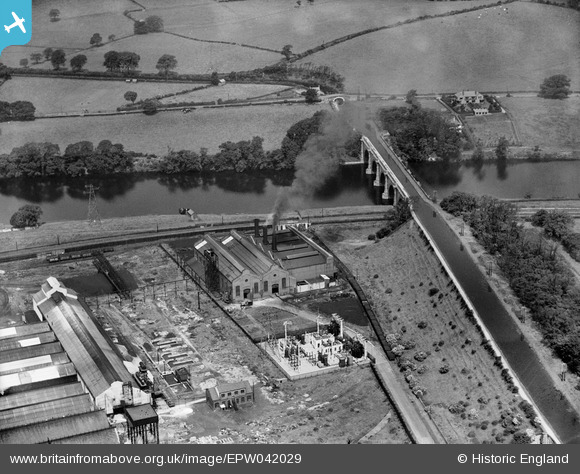
epw042029 ENGLAND (1933). Lancaster Power Station and the Lune Aqueduct, Lancaster, 1933
© Copyright OpenStreetMap contributors and licensed by the OpenStreetMap Foundation. 2025. Cartography is licensed as CC BY-SA.
Details
| Title | [EPW042029] Lancaster Power Station and the Lune Aqueduct, Lancaster, 1933 |
| Reference | EPW042029 |
| Date | June-1933 |
| Link | |
| Place name | LANCASTER |
| Parish | |
| District | |
| Country | ENGLAND |
| Easting / Northing | 348453, 463781 |
| Longitude / Latitude | -2.7877351691481, 54.067202590194 |
| National Grid Reference | SD485638 |
Pins
 Triggy |
Tuesday 11th of February 2014 08:23:54 PM | |
It was the Cellulose Acetate Silk Company from 1928 until they changed their name to Lansil (Lancaster Silk) sometime in the late 30s or early 40s. It was the National Projectile Factory (NPF) from 1916 to 1922, and empty until 1928. The Power Station was built 1916 to power the NPF, and then taken over by Lancaster Corporation to power Lancaster, Morecambe & Heysham. |
 Tim Churchill |
Wednesday 23rd of April 2014 07:52:53 PM |


![[EPW042029] Lancaster Power Station and the Lune Aqueduct, Lancaster, 1933](http://britainfromabove.org.uk/sites/all/libraries/aerofilms-images/public/100x100/EPW/042/EPW042029.jpg)
![[EPW042030] Lancaster Power Station and the Lune Aqueduct, Lancaster, 1933](http://britainfromabove.org.uk/sites/all/libraries/aerofilms-images/public/100x100/EPW/042/EPW042030.jpg)