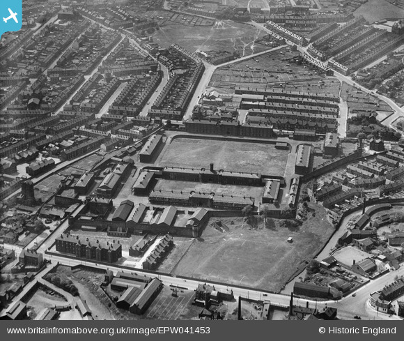
epw041453 ENGLAND (1933). The Burdall's Buildings (formerly Hillsborough Barracks) and environs, Walkley, 1933
© Copyright OpenStreetMap contributors and licensed by the OpenStreetMap Foundation. 2025. Cartography is licensed as CC BY-SA.
Nearby Images (7)
Details
| Title | [EPW041453] The Burdall's Buildings (formerly Hillsborough Barracks) and environs, Walkley, 1933 |
| Reference | EPW041453 |
| Date | June-1933 |
| Link | |
| Place name | WALKLEY |
| Parish | |
| District | |
| Country | ENGLAND |
| Easting / Northing | 433638, 389497 |
| Longitude / Latitude | -1.4940157863668, 53.400962884538 |
| National Grid Reference | SK336895 |
Pins
 colindar |
Tuesday 25th of January 2022 09:19:55 PM | |
 colindar |
Tuesday 25th of January 2022 09:19:22 PM | |
 colindar |
Tuesday 25th of January 2022 09:18:57 PM | |
 colindar |
Tuesday 25th of January 2022 09:17:45 PM | |
 highsidedvehicles |
Thursday 9th of March 2017 06:29:38 PM | |
 highsidedvehicles |
Thursday 9th of March 2017 06:27:07 PM | |
 highsidedvehicles |
Thursday 9th of March 2017 06:24:32 PM | |
 Class31 |
Thursday 12th of May 2016 10:23:53 PM | |
 Class31 |
Thursday 12th of May 2016 10:23:17 PM | |
 Class31 |
Monday 20th of July 2015 02:03:32 PM | |
 Class31 |
Monday 20th of July 2015 01:58:15 PM |


![[EPW041453] The Burdall's Buildings (formerly Hillsborough Barracks) and environs, Walkley, 1933](http://britainfromabove.org.uk/sites/all/libraries/aerofilms-images/public/100x100/EPW/041/EPW041453.jpg)
![[EPW041452] The Burdall's Buildings (formerly Hillsborough Barracks), Walkley, 1933](http://britainfromabove.org.uk/sites/all/libraries/aerofilms-images/public/100x100/EPW/041/EPW041452.jpg)
![[EPW041449] The Burdall's Buildings (formerly Hillsborough Barracks) and environs, Walkley, 1933](http://britainfromabove.org.uk/sites/all/libraries/aerofilms-images/public/100x100/EPW/041/EPW041449.jpg)
![[EPW041454] The Burdall's Buildings (formerly Hillsborough Barracks), Walkley, 1933](http://britainfromabove.org.uk/sites/all/libraries/aerofilms-images/public/100x100/EPW/041/EPW041454.jpg)
![[EPW041450] The Burdall's Buildings (formerly Hillsborough Barracks) and environs, Walkley, 1933](http://britainfromabove.org.uk/sites/all/libraries/aerofilms-images/public/100x100/EPW/041/EPW041450.jpg)
![[EPW041451] The Burdall's Buildings (formerly Hillsborough Barracks) and environs, Walkley, 1933](http://britainfromabove.org.uk/sites/all/libraries/aerofilms-images/public/100x100/EPW/041/EPW041451.jpg)
![[EPW041626] Hillsborough Barracks, Hillsborough Park and environs, Sheffield, 1933](http://britainfromabove.org.uk/sites/all/libraries/aerofilms-images/public/100x100/EPW/041/EPW041626.jpg)