
Scheduled Maintenance
This website will undergo scheduled maintenance on Tuesday, September 10th, between 11:00 and 15:00, as well as on Thursday, September 12th, between 10:00 and 12:00. During this time, services may be temporarily disrupted. We apologise for any inconvenience.
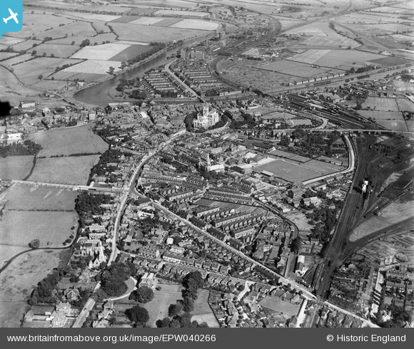
epw040266 ENGLAND (1932). The town, Selby, from the west, 1932
© Copyright OpenStreetMap contributors and licensed by the OpenStreetMap Foundation. 2024. Cartography is licensed as CC BY-SA.
Nearby Images (2)
EPW040266

EPW040265

Details
| Title | [EPW040266] The town, Selby, from the west, 1932 |
| Reference | EPW040266 |
| Date | September-1932 |
| Link | |
| Place name | SELBY |
| Parish | SELBY |
| District | |
| Country | ENGLAND |
| Easting / Northing | 460968, 432052 |
| Longitude / Latitude | -1.0746424276502, 53.781004866103 |
| National Grid Reference | SE610321 |
Pins
 Kelly Stephenson |
Wednesday 2nd of November 2016 01:48:03 AM | |
Kelly Stephenson |
Wednesday 2nd of November 2016 01:39:19 AM | |
Kelly Stephenson |
Wednesday 2nd of November 2016 01:38:27 AM | |
Kelly Stephenson |
Wednesday 2nd of November 2016 01:37:45 AM | |
Kelly Stephenson |
Wednesday 2nd of November 2016 01:35:57 AM | |
Kelly Stephenson |
Wednesday 2nd of November 2016 01:30:16 AM | |
noonday |
Friday 19th of February 2016 08:02:23 PM | |
Bryan |
Saturday 21st of December 2013 07:55:16 PM | |
chaz |
Wednesday 8th of May 2013 11:11:48 AM |
User Comment Contributions
St Mary's church. Leeds Road. |
Kelly Stephenson |
Wednesday 2nd of November 2016 01:34:52 AM |
Westbourne road is after West level crossing. Possibly named Brayton Road when this image was taken. |
Kelly Stephenson |
Wednesday 2nd of November 2016 01:26:28 AM |