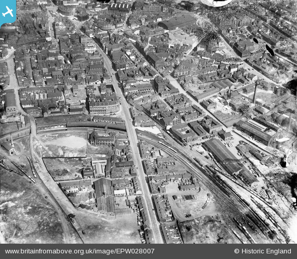
epw028007 ENGLAND (1929). Etruria Road and environs, Hanley, 1929
© Copyright OpenStreetMap contributors and licensed by the OpenStreetMap Foundation. 2025. Cartography is licensed as CC BY-SA.
Details
| Title | [EPW028007] Etruria Road and environs, Hanley, 1929 |
| Reference | EPW028007 |
| Date | July-1929 |
| Link | |
| Place name | HANLEY |
| Parish | |
| District | |
| Country | ENGLAND |
| Easting / Northing | 387998, 347557 |
| Longitude / Latitude | -2.1789598492237, 53.024864064046 |
| National Grid Reference | SJ880476 |
Pins
 bescotbeast |
Sunday 19th of November 2023 01:18:51 PM | |
 bescotbeast |
Sunday 19th of November 2023 01:18:51 PM | |
 GB |
Wednesday 13th of September 2023 05:07:15 PM | |
 silverxmafia |
Wednesday 15th of February 2023 10:55:23 PM | |
 gbaddley |
Saturday 21st of November 2015 04:16:49 PM | |
 bescotbeast |
Friday 19th of September 2014 01:10:48 AM | |
 bescotbeast |
Friday 19th of September 2014 01:10:26 AM | |
 IvanSherratt |
Tuesday 11th of March 2014 07:37:26 PM | |
 bescotbeast |
Tuesday 4th of March 2014 12:59:33 AM | |
 gbaddley |
Thursday 7th of November 2013 07:42:06 PM | |
 gbaddley |
Thursday 7th of November 2013 06:10:32 PM |


![[EPW028007] Etruria Road and environs, Hanley, 1929](http://britainfromabove.org.uk/sites/all/libraries/aerofilms-images/public/100x100/EPW/028/EPW028007.jpg)
![[EPW028010] The town centre, Hanley, 1929](http://britainfromabove.org.uk/sites/all/libraries/aerofilms-images/public/100x100/EPW/028/EPW028010.jpg)
![[EPW028009] The Shelton Iron and Steel Works and environs, Hanley, 1929](http://britainfromabove.org.uk/sites/all/libraries/aerofilms-images/public/100x100/EPW/028/EPW028009.jpg)