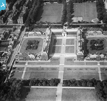
epw024949 ENGLAND (1928). The Royal Hospital, Chelsea, 1928
© Copyright OpenStreetMap contributors and licensed by the OpenStreetMap Foundation. 2024. Cartography is licensed as CC BY-SA.
Nearby Images (16)
Details
| Title | [EPW024949] The Royal Hospital, Chelsea, 1928 |
| Reference | EPW024949 |
| Date | 6-October-1928 |
| Link | |
| Place name | CHELSEA |
| Parish | |
| District | |
| Country | ENGLAND |
| Easting / Northing | 528007, 178042 |
| Longitude / Latitude | -0.15616033135767, 51.486336823635 |
| National Grid Reference | TQ280780 |
Pins
 Class31 |
Wednesday 21st of November 2012 05:20:24 PM | |
 Class31 |
Wednesday 21st of November 2012 05:18:55 PM | |
 Class31 |
Wednesday 21st of November 2012 05:18:33 PM | |
 RQMSRHC |
Tuesday 26th of June 2012 08:03:37 AM | |
 RQMSRHC |
Tuesday 26th of June 2012 08:02:26 AM |
User Comment Contributions
Royal Hospital, Chelsea, 23/09/2014 |
 Class31 |
Monday 29th of September 2014 02:49:00 PM |
Royal Hospital, Chelsea, 23/09/2014 |
 Class31 |
Monday 29th of September 2014 02:48:29 PM |
Royal Hospital, Chelsea, 23/09/2014 |
 Class31 |
Monday 29th of September 2014 02:48:01 PM |
Royal Hospital, Chelsea, 23/09/2014 |
 Class31 |
Monday 29th of September 2014 02:47:28 PM |
Royal Hospital, Chelsea, 23/09/2014 |
 Class31 |
Monday 29th of September 2014 02:46:42 PM |
Royal Hospital, Chelsea, 23/09/2014 |
 Class31 |
Tuesday 23rd of September 2014 10:14:01 PM |
Royal Hospital, Chelsea, 23/09/2014 |
 Class31 |
Tuesday 23rd of September 2014 10:12:15 PM |
 RQMSRHC |
Wednesday 27th of June 2012 10:02:02 AM |


![[EPW024949] The Royal Hospital, Chelsea, 1928](http://britainfromabove.org.uk/sites/all/libraries/aerofilms-images/public/100x100/EPW/024/EPW024949.jpg)
![[EAW049458] The Chelsea Flower Show, Royal Hospital, Ranelagh Gardens and environs, Chelsea, 1953](http://britainfromabove.org.uk/sites/all/libraries/aerofilms-images/public/100x100/EAW/049/EAW049458.jpg)
![[EAW041932] The Royal Hospital, Chelsea, 1952](http://britainfromabove.org.uk/sites/all/libraries/aerofilms-images/public/100x100/EAW/041/EAW041932.jpg)
![[EAW049459] The Chelsea Flower Show, Royal Hospital, Ranelagh Gardens and environs, Chelsea, 1953](http://britainfromabove.org.uk/sites/all/libraries/aerofilms-images/public/100x100/EAW/049/EAW049459.jpg)
![[EAW018333] The Royal Hospital, Chelsea, 1948. This image has been produced from a print.](http://britainfromabove.org.uk/sites/all/libraries/aerofilms-images/public/100x100/EAW/018/EAW018333.jpg)
![[EAW018334] The Royal Hospital, Chelsea, 1948. This image has been produced from a print.](http://britainfromabove.org.uk/sites/all/libraries/aerofilms-images/public/100x100/EAW/018/EAW018334.jpg)
![[EAW018335] The Royal Hospital, Chelsea, 1948. This image has been produced from a print.](http://britainfromabove.org.uk/sites/all/libraries/aerofilms-images/public/100x100/EAW/018/EAW018335.jpg)
![[EAW049461] The Chelsea Flower Show, Royal Hospital and environs, Chelsea, 1953](http://britainfromabove.org.uk/sites/all/libraries/aerofilms-images/public/100x100/EAW/049/EAW049461.jpg)
![[EAW049460] The Chelsea Flower Show, Royal Hospital and environs, Chelsea, 1953](http://britainfromabove.org.uk/sites/all/libraries/aerofilms-images/public/100x100/EAW/049/EAW049460.jpg)
![[EPW024249] The Royal Hospital, Chelsea, 1928](http://britainfromabove.org.uk/sites/all/libraries/aerofilms-images/public/100x100/EPW/024/EPW024249.jpg)
![[EPW037942] Chelsea, The Chelsea Flower Show, 1932](http://britainfromabove.org.uk/sites/all/libraries/aerofilms-images/public/100x100/EPW/037/EPW037942.jpg)
![[EAW049387] The Chelsea Flower Show, Royal Hospital and Ranelagh Gardens, Chelsea, 1953](http://britainfromabove.org.uk/sites/all/libraries/aerofilms-images/public/100x100/EAW/049/EAW049387.jpg)
![[EAW049386] The Chelsea Flower Show, Royal Hospital and Ranelagh Gardens, Chelsea, 1953](http://britainfromabove.org.uk/sites/all/libraries/aerofilms-images/public/100x100/EAW/049/EAW049386.jpg)
![[EPW037943] Chelsea, The Chelsea Flower Show, 1932](http://britainfromabove.org.uk/sites/all/libraries/aerofilms-images/public/100x100/EPW/037/EPW037943.jpg)
![[EAW049388] The Chelsea Flower Show, Royal Hospital, Ranelagh Gardens and the River Thames, Chelsea, 1953](http://britainfromabove.org.uk/sites/all/libraries/aerofilms-images/public/100x100/EAW/049/EAW049388.jpg)
![[EAW041933] The Royal Hospital, Burton's Court and environs, Chelsea, 1952](http://britainfromabove.org.uk/sites/all/libraries/aerofilms-images/public/100x100/EAW/041/EAW041933.jpg)
