
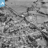
epw023486 ENGLAND (1928). The Staines Linoleum Company Works and High Street, Staines, 1928

© Copyright OpenStreetMap contributors and licensed by the OpenStreetMap Foundation. 2025. Cartography is licensed as CC BY-SA.
Nearby Images (17)
EPW023486

EPW023490

EPW023481

EPW023477
EPW009569

EPW061665

EPW023480

EPW061669

EPW009567

EPW023473

EPW023488

EPW009570

EPW023491

EPW023472

EPW023483

EPW061672

EPW061674

Details
| Title | [EPW023486] The Staines Linoleum Company Works and High Street, Staines, 1928 |
| Reference | EPW023486 |
| Date | September-1928 |
| Link | |
| Place name | STAINES |
| Parish | |
| District | |
| Country | ENGLAND |
| Easting / Northing | 503580, 171666 |
| Longitude / Latitude | -0.50973695648972, 51.434022766375 |
| National Grid Reference | TQ036717 |
Pins
 Muggerbee |
Sunday 5th of November 2023 07:45:40 PM | |
Cuttin' |
Monday 28th of March 2022 02:45:48 PM | |
Leslie B |
Thursday 28th of December 2017 01:11:19 AM | |
 Class31 |
Tuesday 15th of September 2015 03:45:52 PM | |
Billy121 |
Thursday 17th of July 2014 11:01:17 AM | |
John |
Monday 7th of January 2013 10:47:54 PM | |
hmrspaul |
Sunday 1st of July 2012 11:21:21 PM |
