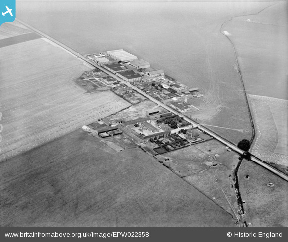
epw022358 ENGLAND (1928). Hainault Farm and the Hainault Tarpaulin Works, Hainault, 1928
© Copyright OpenStreetMap contributors and licensed by the OpenStreetMap Foundation. 2025. Cartography is licensed as CC BY-SA.
Details
| Title | [EPW022358] Hainault Farm and the Hainault Tarpaulin Works, Hainault, 1928 |
| Reference | EPW022358 |
| Date | August-1928 |
| Link | |
| Place name | HAINAULT |
| Parish | |
| District | |
| Country | ENGLAND |
| Easting / Northing | 546603, 190584 |
| Longitude / Latitude | 0.11674131292941, 51.594527849991 |
| National Grid Reference | TQ466906 |
Pins
 Class31 |
Thursday 30th of August 2012 10:39:58 AM | |
 Class31 |
Thursday 30th of August 2012 10:35:17 AM | |
 Class31 |
Thursday 30th of August 2012 10:32:13 AM | |
 Mike |
Tuesday 31st of July 2012 11:04:12 AM | |
 chiffchaffbirdy |
Wednesday 18th of July 2012 03:57:14 PM | |
 chiffchaffbirdy |
Wednesday 18th of July 2012 03:54:28 PM | |
The photo doesn't show a large enough area to assume the whole region is flat. There are level areas as big as this on Salisbury Plain, my first thought was that this is Larkhill. Probably not. |
 Tiny Tim |
Saturday 21st of July 2012 02:47:59 PM |
 HydeParkDave |
Monday 16th of July 2012 11:51:55 AM | |
 Eton Slaphead |
Monday 9th of July 2012 09:25:42 PM | |
I agree. I've also looked for a windsock, but couldn't find one (it would make quite a roomy airfield). |
 BigglesH |
Sunday 15th of July 2012 05:10:24 AM |
User Comment Contributions
.jpg) A close up aerial photograph of what had been Hainault Farm Aerodrome, Hangars and associated buildings when owned by John Smith & Company as their Hainault Works. |
 Henry J Foxwood |
Friday 25th of July 2014 04:31:51 PM |
Lynda Tubbs |
Tuesday 1st of April 2014 03:19:38 PM | |
I agree this is definitely the old RFC/RAF Hainault Farm Aerodrome. Sopwith Camels were based there to intercept the German Gotha bombers raiding London. It was closed as an active airfield after the end of the 1st WW in 1919. Soon after this the aerodrome buildings were purchased by by John Smith & Co Ltd of Shaftesbury Avenue, as their new Hainault Works. Hence there aren't any windsocks or any other identification of an active airfield. The airfield land reverted to farm land after the airfield closed. John Smith's manufactured tents, tarpaulins, marquees, aircraft hangars and other heavy textile products. |
 Henry J Foxwood |
Tuesday 1st of April 2014 03:17:02 PM |
Read the Government assessment of Hainault Farm: http://www.prcraig.com/hainaultfarmstats.htm |
Lynda Tubbs |
Tuesday 1st of April 2014 03:17:02 PM |
It was not an airfield during WW2. It continued as the John Smith & Co factory becoming part of the Black & Edgington Group in about the 1960s. A new airfield RAF Fairlop with hard runways and perimeter track was built nearby during WW2. |
 Henry J Foxwood |
Thursday 6th of December 2012 08:25:24 PM |
It was still in use in ww2 |
 trigger |
Wednesday 28th of November 2012 05:13:43 PM |
Hainault Farm,Hainault Rd,not sure of postal town,but NE of Aldborough Hatch,Essex.This was the site of Chigwell airfield in WW2. |
 martyk |
Wednesday 24th of October 2012 09:42:44 AM |
I can confirm that I have checked this out and it is Hainault Farm, Romford. Some of the cottages are still present today. |
 Class31 |
Thursday 30th of August 2012 10:43:44 AM |
Hi martyk, another great "spot", thanks. We'll update the catalogue and post the new location information here in due course. Great job. Yours, Katy Britain from Above Cataloguing Team Leader |
Katy Whitaker |
Wednesday 24th of October 2012 09:42:44 AM |
Definitely Hainault Farm at Ilford/Chigwell, a World War I airfield |
 DaveW |
Thursday 11th of October 2012 12:24:35 PM |
This is a view looking north-east over Hainault Farm in Hainault Road, Ilford, Essex (in the London Borough of Redbridge). The land, and some of the buildings, on the far side of the road, north-east of the farm, were part of the Royal Flying Corps Hainault Farm aerodrome in the First World War. Hainault Road itself is not a Roman road, but dates from the mid 1850s, like the farm, when much of Hainault Forest was disafforested and turned over to agriculture. Several long straight roads now bisect the area of the former forest. |
 Alan S |
Thursday 6th of September 2012 05:35:34 PM |


