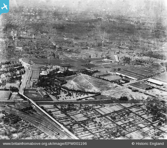
epw001196 ENGLAND (1920). Works in the Mile Lane and Quinton Road area, Coventry, 1920
© Copyright OpenStreetMap contributors and licensed by the OpenStreetMap Foundation. 2024. Cartography is licensed as CC BY-SA.
Nearby Images (25)
Details
| Title | [EPW001196] Works in the Mile Lane and Quinton Road area, Coventry, 1920 |
| Reference | EPW001196 |
| Date | May-1920 |
| Link | |
| Place name | COVENTRY |
| Parish | |
| District | |
| Country | ENGLAND |
| Easting / Northing | 433732, 278331 |
| Longitude / Latitude | -1.5041439436985, 52.401571985714 |
| National Grid Reference | SP337783 |
Pins
 JG |
Thursday 28th of August 2014 03:52:00 PM | |
 JG |
Monday 10th of February 2014 10:36:12 PM | |
went to the school 1960 from the picture had nt changed atall |
 tim |
Monday 24th of March 2014 10:16:13 PM |
 dutchman |
Wednesday 22nd of May 2013 02:23:44 PM | |
 Midland Red |
Tuesday 21st of May 2013 09:38:21 PM | |
 Midland Red |
Tuesday 21st of May 2013 09:37:59 PM | |
 Midland Red |
Tuesday 21st of May 2013 09:37:21 PM | |
 Midland Red |
Tuesday 21st of May 2013 09:36:57 PM | |
 Midland Red |
Tuesday 21st of May 2013 09:36:09 PM |


![[EPW001196] Works in the Mile Lane and Quinton Road area, Coventry, 1920](http://britainfromabove.org.uk/sites/all/libraries/aerofilms-images/public/100x100/EPW/001/EPW001196.jpg)
![[EAW016165] The Armstrong Siddeley Motor Works, Coventry, 1948. This image has been produced from a print.](http://britainfromabove.org.uk/sites/all/libraries/aerofilms-images/public/100x100/EAW/016/EAW016165.jpg)
![[EAW016176] Morris Motors, the Armstrong Siddeley Motor Works and environs, Coventry, from the south-west, 1948. This image has been produced from a damaged negative.](http://britainfromabove.org.uk/sites/all/libraries/aerofilms-images/public/100x100/EAW/016/EAW016176.jpg)
![[EAW016174] The Armstrong Siddeley Motor Works, Coventry, 1948. This image has been produced from a damaged negative.](http://britainfromabove.org.uk/sites/all/libraries/aerofilms-images/public/100x100/EAW/016/EAW016174.jpg)
![[EAW016163] The Armstrong Siddeley Motor Works, Coventry, 1948. This image has been produced from a print.](http://britainfromabove.org.uk/sites/all/libraries/aerofilms-images/public/100x100/EAW/016/EAW016163.jpg)
![[EAW016175] The Armstrong Siddeley Motor Works, Coventry, 1948. This image has been produced from a damaged negative.](http://britainfromabove.org.uk/sites/all/libraries/aerofilms-images/public/100x100/EAW/016/EAW016175.jpg)
![[EAW016166] The Armstrong Siddeley Motor Works, Coventry, 1948. This image has been produced from a print.](http://britainfromabove.org.uk/sites/all/libraries/aerofilms-images/public/100x100/EAW/016/EAW016166.jpg)
![[EAW016168] The Armstrong Siddeley Motor Works, Coventry, 1948. This image has been produced from a damaged negative.](http://britainfromabove.org.uk/sites/all/libraries/aerofilms-images/public/100x100/EAW/016/EAW016168.jpg)
![[EAW016164] The Armstrong Siddeley Motor Works, Coventry, 1948. This image has been produced from a print.](http://britainfromabove.org.uk/sites/all/libraries/aerofilms-images/public/100x100/EAW/016/EAW016164.jpg)
![[EAW016167] The Armstrong Siddeley Motor Works, Coventry, 1948. This image has been produced from a print.](http://britainfromabove.org.uk/sites/all/libraries/aerofilms-images/public/100x100/EAW/016/EAW016167.jpg)
![[EPW031348] The Morris Motor Body Works (Hollick and Pratt Ltd) and environs, Cheylesmore, 1930](http://britainfromabove.org.uk/sites/all/libraries/aerofilms-images/public/100x100/EPW/031/EPW031348.jpg)
![[EPW031349] The Morris Motor Body Works (Hollick and Pratt Ltd) and environs, Cheylesmore, 1930](http://britainfromabove.org.uk/sites/all/libraries/aerofilms-images/public/100x100/EPW/031/EPW031349.jpg)
![[EPW031328] The Morris Motor Body Works (Hollick and Pratt Ltd) and environs, Cheylesmore, 1930](http://britainfromabove.org.uk/sites/all/libraries/aerofilms-images/public/100x100/EPW/031/EPW031328.jpg)
![[EPW031327] The Morris Motor Body Works (Hollick and Pratt Ltd) and environs, Cheylesmore, 1930](http://britainfromabove.org.uk/sites/all/libraries/aerofilms-images/public/100x100/EPW/031/EPW031327.jpg)
![[EPW031324] The Morris Motor Body Works (Hollick and Pratt Ltd), Cheylesmore, 1930](http://britainfromabove.org.uk/sites/all/libraries/aerofilms-images/public/100x100/EPW/031/EPW031324.jpg)
![[EPW061112] Quinton Road, Mile Lane and the city, Coventry, from the south-east, 1939. This image has been affected by flare.](http://britainfromabove.org.uk/sites/all/libraries/aerofilms-images/public/100x100/EPW/061/EPW061112.jpg)
![[EPW021003] Burlington Motor Carriage Works and Armstrong Siddeley Motor Works, Coventry, 1928](http://britainfromabove.org.uk/sites/all/libraries/aerofilms-images/public/100x100/EPW/021/EPW021003.jpg)
![[EPW031326] The Morris Motor Body Works (Hollick and Pratt Ltd) and environs, Cheylesmore, 1930](http://britainfromabove.org.uk/sites/all/libraries/aerofilms-images/public/100x100/EPW/031/EPW031326.jpg)
![[EPW019272] The Morris Motors Works (Hollick and Pratt), Cheylesmore, 1927](http://britainfromabove.org.uk/sites/all/libraries/aerofilms-images/public/100x100/EPW/019/EPW019272.jpg)
![[EAW016173] The Burlington Motor Carriage Works, Armstrong Siddeley Motor Works and environs, Coventry, from the south-west, 1948. This image has been produced from a damaged negative.](http://britainfromabove.org.uk/sites/all/libraries/aerofilms-images/public/100x100/EAW/016/EAW016173.jpg)
![[EPW031325] The Morris Motor Body Works (Hollick and Pratt Ltd) and environs, Cheylesmore, 1930](http://britainfromabove.org.uk/sites/all/libraries/aerofilms-images/public/100x100/EPW/031/EPW031325.jpg)
![[EPW010513] The Burlington Works and Morris Motors Body Repair Works, Coventry, 1924](http://britainfromabove.org.uk/sites/all/libraries/aerofilms-images/public/100x100/EPW/010/EPW010513.jpg)
![[EPW010512] The Burlington Works, Coventry, 1924](http://britainfromabove.org.uk/sites/all/libraries/aerofilms-images/public/100x100/EPW/010/EPW010512.jpg)
![[EPW010572] The Burlington Motor Carriage Works and london Road Cemetery, Coventry, 1924. This image has been produced from a print affected by flare.](http://britainfromabove.org.uk/sites/all/libraries/aerofilms-images/public/100x100/EPW/010/EPW010572.jpg)
![[EAW016162] The Burlington Motor Carriage Works, Coventry, 1948. This image has been produced from a damaged negative.](http://britainfromabove.org.uk/sites/all/libraries/aerofilms-images/public/100x100/EAW/016/EAW016162.jpg)