
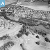
eaw050737 ENGLAND (1953). The site of Betchworth Castle, Brockham, 1953

© Copyright OpenStreetMap contributors and licensed by the OpenStreetMap Foundation. 2025. Cartography is licensed as CC BY-SA.
Nearby Images (4)
EAW050737

EAW050738

EAW048822
EAW048821

Details
| Title | [EAW050737] The site of Betchworth Castle, Brockham, 1953 |
| Reference | EAW050737 |
| Date | 15-July-1953 |
| Link | |
| Place name | BROCKHAM |
| Parish | BROCKHAM |
| District | |
| Country | ENGLAND |
| Easting / Northing | 519026, 150043 |
| Longitude / Latitude | -0.29483393648136, 51.236623945808 |
| National Grid Reference | TQ190500 |
Pins
Be the first to add a comment to this image!