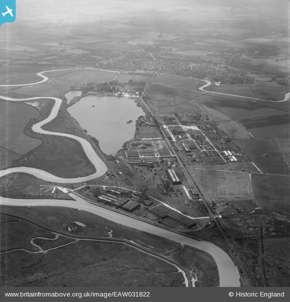
eaw031822 ENGLAND (1950). Industrial premises and Stonar Lake, Great Stonar, 1950
© Copyright OpenStreetMap contributors and licensed by the OpenStreetMap Foundation. 2024. Cartography is licensed as CC BY-SA.
Nearby Images (7)
Details
| Title | [EAW031822] Industrial premises and Stonar Lake, Great Stonar, 1950 |
| Reference | EAW031822 |
| Date | 14-August-1950 |
| Link | |
| Place name | GREAT STONAR |
| Parish | SANDWICH |
| District | |
| Country | ENGLAND |
| Easting / Northing | 633483, 159468 |
| Longitude / Latitude | 1.3487626877788, 51.285900715132 |
| National Grid Reference | TR335595 |
Pins
 Matt Aldred edob.mattaldred.com |
Thursday 7th of March 2024 09:51:10 AM | |
 Matt Aldred edob.mattaldred.com |
Wednesday 6th of September 2023 01:26:40 PM | |
 vulcanone |
Saturday 14th of January 2017 01:51:47 PM | |
 vulcanone |
Saturday 14th of January 2017 12:44:46 PM | |
 vulcanone |
Saturday 14th of January 2017 12:40:45 PM |


![[EAW031822] Industrial premises and Stonar Lake, Great Stonar, 1950](http://britainfromabove.org.uk/sites/all/libraries/aerofilms-images/public/100x100/EAW/031/EAW031822.jpg)
![[EAW031819] The Engineering and Rubber Works and the Shuttlecock Works, Great Stonar, 1950. This image was marked by Aerofilms Ltd for photo editing.](http://britainfromabove.org.uk/sites/all/libraries/aerofilms-images/public/100x100/EAW/031/EAW031819.jpg)
![[EAW031825] Industrial premises and Stonar Lake, Great Stonar, 1950](http://britainfromabove.org.uk/sites/all/libraries/aerofilms-images/public/100x100/EAW/031/EAW031825.jpg)
![[EAW031816] The Engineering and Rubber Works and the Shuttlecock Works, Great Stonar, 1950. This image was marked by Aerofilms Ltd for photo editing.](http://britainfromabove.org.uk/sites/all/libraries/aerofilms-images/public/100x100/EAW/031/EAW031816.jpg)
![[EAW031820] The Engineering and Rubber Works and the Shuttlecock Works, Great Stonar, 1950. This image was marked by Aerofilms Ltd for photo editing.](http://britainfromabove.org.uk/sites/all/libraries/aerofilms-images/public/100x100/EAW/031/EAW031820.jpg)
![[EAW031821] The Engineering and Rubber Works and the Shuttlecock Works, Great Stonar, 1950. This image was marked by Aerofilms Ltd for photo editing.](http://britainfromabove.org.uk/sites/all/libraries/aerofilms-images/public/100x100/EAW/031/EAW031821.jpg)
![[EAW031818] The Engineering and Rubber Works and the Shuttlecock Works, Great Stonar, 1950. This image was marked by Aerofilms Ltd for photo editing.](http://britainfromabove.org.uk/sites/all/libraries/aerofilms-images/public/100x100/EAW/031/EAW031818.jpg)