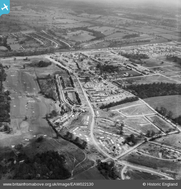
eaw022130 ENGLAND (1949). The South Oxhey Housing Estate under construction around Hayling Road, South Oxhey, 1949
© Copyright OpenStreetMap contributors and licensed by the OpenStreetMap Foundation. 2025. Cartography is licensed as CC BY-SA.
Details
| Title | [EAW022130] The South Oxhey Housing Estate under construction around Hayling Road, South Oxhey, 1949 |
| Reference | EAW022130 |
| Date | 14-April-1949 |
| Link | |
| Place name | SOUTH OXHEY |
| Parish | WATFORD RURAL |
| District | |
| Country | ENGLAND |
| Easting / Northing | 510950, 193480 |
| Longitude / Latitude | -0.39686931404524, 51.6287121659 |
| National Grid Reference | TQ110935 |
Pins
 ordinarybloke |
Tuesday 15th of August 2017 12:14:05 PM | |
 Neil Hamilton |
Monday 23rd of December 2013 01:56:25 PM | |
 John Swain |
Thursday 19th of December 2013 04:07:09 PM | |
 Neil Hamilton |
Thursday 19th of December 2013 04:00:13 PM | |
 John Swain |
Thursday 19th of December 2013 03:58:19 PM | |
 Neil Hamilton |
Thursday 19th of December 2013 03:58:07 PM | |
 Neil Hamilton |
Thursday 19th of December 2013 03:56:45 PM | |
 John Swain |
Thursday 19th of December 2013 03:54:11 PM | |
 John Swain |
Thursday 19th of December 2013 03:49:11 PM | |
 John Swain |
Thursday 19th of December 2013 03:47:30 PM | |
 John Swain |
Thursday 19th of December 2013 03:46:11 PM | |
 John Swain |
Thursday 19th of December 2013 03:37:22 PM | |
 John Swain |
Thursday 19th of December 2013 03:34:54 PM | |
 John Swain |
Thursday 19th of December 2013 03:30:19 PM | |
 John Swain |
Thursday 19th of December 2013 03:25:24 PM | |
 John Swain |
Thursday 19th of December 2013 03:20:12 PM | |
 John Swain |
Thursday 19th of December 2013 03:17:01 PM | |
 John Swain |
Thursday 19th of December 2013 03:13:51 PM | |
 John Swain |
Thursday 19th of December 2013 03:08:42 PM | |
 John Swain |
Thursday 19th of December 2013 03:07:24 PM | |
 John Swain |
Thursday 19th of December 2013 03:06:18 PM | |
 John Swain |
Thursday 19th of December 2013 03:05:09 PM | |
 John Swain |
Thursday 19th of December 2013 03:03:58 PM | |
 John Swain |
Thursday 19th of December 2013 03:02:12 PM | |
 John Swain |
Thursday 19th of December 2013 03:01:12 PM | |
 John Swain |
Thursday 19th of December 2013 03:00:09 PM | |
 John Swain |
Thursday 19th of December 2013 02:57:42 PM | |
 John Swain |
Thursday 19th of December 2013 02:55:51 PM | |
 John Swain |
Thursday 19th of December 2013 02:53:05 PM | |
 John Swain |
Thursday 19th of December 2013 02:51:23 PM | |
 John Swain |
Thursday 19th of December 2013 02:48:32 PM | |
 John Swain |
Thursday 19th of December 2013 02:47:01 PM | |
 John Swain |
Thursday 19th of December 2013 02:38:15 PM |
User Comment Contributions
 John Swain |
Thursday 19th of December 2013 04:16:38 PM | |
 John Swain |
Thursday 19th of December 2013 04:10:54 PM | |
After years of planning and debate, building of this vast new London County Council estate commenced in October 1946. The first tenants, Mr & Mrs Caldwell, moved into their new, brick-built house on Wednesday, November 26th, 1947, at 50, Hayling Road. These images were taken approximately half way through the construction of Oxhey Estate and 1,468 of the planned 4,200 dwellings had been finished by September 1949. However, the provision of social amenities was totally inadequate: there were no schools, shops, pavements, street lights, telephones, churches or clubs until the early 1950s. When the main phase of building was finished in 1953, the population had reached a peak of 17,000, compared with only 7,000 when this photograph was taken. |
 John Swain |
Thursday 19th of December 2013 02:37:16 PM |


![[EAW022130] The South Oxhey Housing Estate under construction around Hayling Road, South Oxhey, 1949](http://britainfromabove.org.uk/sites/all/libraries/aerofilms-images/public/100x100/EAW/022/EAW022130.jpg)
![[EAW022132] The South Oxhey Housing Estate under construction around Hayling Road, South Oxhey, 1949](http://britainfromabove.org.uk/sites/all/libraries/aerofilms-images/public/100x100/EAW/022/EAW022132.jpg)

