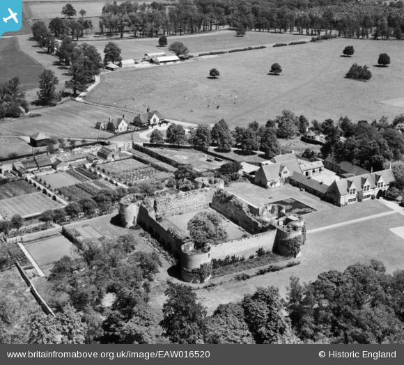
© Copyright OpenStreetMap contributors and licensed by the OpenStreetMap Foundation. 2025. Cartography is licensed as CC BY-SA.
Details
Title |
[EAW016520] Barnwell Castle and Manor, Barnwell, 1948 |
Reference |
EAW016520 |
Date |
9-November-1948 |
Link |
|
Place name |
BARNWELL |
Parish |
BARNWELL |
District |
|
Country |
ENGLAND |
Easting / Northing |
504966, 285271 |
Longitude / Latitude |
-0.45510625136559, 52.454920730575 |
National Grid Reference |
TL050853 |
Pins
![](/sites/default/files/activity_icons/annotate.png) This path leads to Barnwell Manor, which is entirely off the picture. |
![](/sites/default/files/pictures/default-profile-picture.png) totoro |
Wednesday 2nd of July 2014 09:09:40 PM |
![](/sites/default/files/activity_icons/annotate.png) Barnwell Castle - 6 Well Lane, Barnwell, Northamptonshire PE8 5PS
Grade 1 listed building and scheduled monument - English Heritage Building ID: 232573
The castle is privately owned and access is not permitted.
Monument listing - Formal gardens to Barnwell Castle, laid out from 1913 to the 1920s by Horace Czarnikov, incorporating a raised walk constructed circa 1613 by Thomas Drew.
Castle Listing:
Castle. Built about 1266 by Berenger Le Moyne; some building work may have taken place within the castle during C16:-
In 1568, Sir Edward Montagu founded a Tudor manor house, in the outer court and demolished all the buildings within the courtyard.
Entrance front, to east, has gate-house, to far left of curtain wall, with flanking semi-circular towers.
The towers and curtain walls were originally
probably higher and would have had a castellated parapet. The building date of 1266 is derived from a Jury statement of 1276 which records that Berenger Le Moyne had built a castle 10 years earlier.
The castle was probably used as a farmyard during C18 and C19 with access through the break in the west curtain wall. |
![](/sites/default/files/pictures/default-profile-picture.png) totoro |
Wednesday 2nd of July 2014 09:07:46 PM |
User Comment Contributions