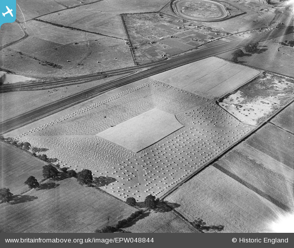
EPW048844 ENGLAND (1935). Harvesting a field at The Parks, Dunscroft, 1935
© Copyright OpenStreetMap contributors and licensed by the OpenStreetMap Foundation. 2025. Cartography is licensed as CC BY-SA.
Details
| Title | [EPW048844] Harvesting a field at The Parks, Dunscroft, 1935 |
| Reference | EPW048844 |
| Date | August-1935 |
| Link | |
| Place name | DUNSCROFT |
| Parish | HATFIELD |
| District | |
| Country | ENGLAND |
| Easting / Northing | 464134, 410134 |
| Longitude / Latitude | -1.031129386138, 53.583627758507 |
| National Grid Reference | SE641101 |
Pins
 Maurice |
Friday 14th of June 2013 04:45:36 PM | |
 BigglesH |
Wednesday 15th of May 2013 01:39:57 AM | |
 BigglesH |
Wednesday 15th of May 2013 01:35:48 AM | |
I think it might be a reaper and binder. That is a machine that cut the crop and bound it into sheaves before dropping it on the ground. The sheaves were then collected together and made into stooks to aid drying. The outer part of the field has already been stooked. |
 Maurice |
Friday 14th of June 2013 04:41:42 PM |
Considering the changes that have taken place in agriculture, especially with regard to filed sizes it is surprising to see this field is the same shape today.... a shape that gives the distinctive pattern to the cropping.... the area to the north will be harvested next without the repeated pattern of the sloping corner! |
 Maurice |
Friday 14th of June 2013 05:09:39 PM |
 Chris Willis |
Monday 13th of May 2013 05:01:18 PM | |
Line from Doncaster (front left) to Goole join by the two track line from Wakefield, that skirts around the north of Doncaster. Both lines are still there today with the same number of tracks. |
 Maurice |
Friday 14th of June 2013 05:06:53 PM |
 Chris Willis |
Monday 13th of May 2013 04:59:54 PM | |
Trotting track maybe? As a sport it went out of fashion and a number of trotting tracks became greyhound tracks, I believe. There's some good early Pathe footage of the past-time. Still no help on location, sorry! Yours, Katy |
Katy Whitaker |
Monday 13th of May 2013 05:21:24 PM |
Stainforth 'Greyhound Stadium' still there today after being modernized. |
 rb13013 |
Tuesday 15th of December 2015 07:39:09 PM |
User Comment Contributions
Photo is taken from location 464332,409219 which is just above Parks farm which is to the west of Dunscroft. The photo is looking North. The track is Stainforth Stadium. |
 Pennine Rambler |
Friday 2nd of August 2013 10:29:43 PM |
I think we are looking at Doncaster Greyhound Stadium |
 BigglesH |
Tuesday 2nd of July 2013 03:07:19 PM |
Thank you for identifying the location of this image. We'll update the catalogue and post the new record here in due course. Yours, Katy Britain from Above Cataloguing Team Leader |
Katy Whitaker |
Tuesday 2nd of July 2013 03:07:19 PM |
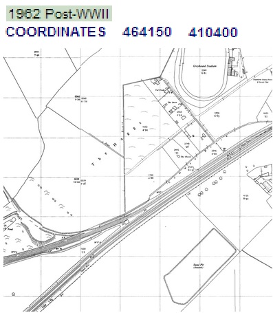
 BigglesH has done the work and is due the credit. I attach relevant map just as an extra. |
 ewnmcg |
Saturday 1st of June 2013 08:23:54 PM |
I think this photo taken from about 5 or 6000 ft and that photo was taken on spec (i.e. not requested). |
 BigglesH |
Wednesday 15th of May 2013 01:49:20 AM |

