
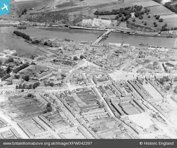
xpw042397 IRELAND (1933). General View, Waterford, Waterford, Ireland, 1933. Oblique aerial photograph taken facing North.
© Copyright OpenStreetMap contributors and licensed by the OpenStreetMap Foundation. 2026. Cartography is licensed as CC BY-SA.
Details
| Title | [XPW042397] General View, Waterford, Waterford, Ireland, 1933. Oblique aerial photograph taken facing North. |
| Reference | XPW042397 |
| Date | 1933 |
| Link | |
| Place name | WATERFORD |
| Parish | IRELAND |
| District | |
| Country | IRELAND |
| Easting / Northing | 50745, 274568 |
| Longitude / Latitude | -7.119879, 52.25806 |
| National Grid Reference |
Pins

ofarrl1960 |
Saturday 11th of November 2017 06:52:49 PM | |
|
ofarrl1960 |
Saturday 11th of November 2017 06:51:34 PM | |
|
ofarrl1960 |
Saturday 11th of November 2017 06:49:04 PM | |
|
ofarrl1960 |
Saturday 11th of November 2017 06:46:56 PM | |

John Swain |
Thursday 9th of October 2014 12:07:41 PM | |
|
John Swain |
Thursday 9th of October 2014 12:05:39 PM | |
|
John Swain |
Thursday 9th of October 2014 12:03:35 PM | |
|
John Swain |
Thursday 9th of October 2014 12:02:36 PM | |
|
John Swain |
Thursday 9th of October 2014 12:01:16 PM | |
|
John Swain |
Thursday 9th of October 2014 11:58:18 AM | |
|
John Swain |
Thursday 9th of October 2014 11:57:20 AM | |
|
John Swain |
Thursday 9th of October 2014 11:56:42 AM | |
|
John Swain |
Thursday 9th of October 2014 11:55:20 AM | |
|
John Swain |
Thursday 9th of October 2014 11:54:44 AM | |
|
John Swain |
Thursday 9th of October 2014 11:53:56 AM | |
|
John Swain |
Thursday 9th of October 2014 11:53:20 AM | |
|
John Swain |
Thursday 9th of October 2014 11:51:20 AM | |
|
John Swain |
Thursday 9th of October 2014 11:48:25 AM | |
|
John Swain |
Thursday 9th of October 2014 11:47:48 AM | |
|
John Swain |
Thursday 9th of October 2014 11:47:12 AM | |
|
John Swain |
Thursday 9th of October 2014 11:45:47 AM | |
|
John Swain |
Thursday 9th of October 2014 11:43:47 AM | |
|
John Swain |
Thursday 9th of October 2014 11:43:05 AM | |
|
John Swain |
Thursday 9th of October 2014 11:42:37 AM | |
|
John Swain |
Thursday 9th of October 2014 11:41:55 AM | |
|
John Swain |
Thursday 9th of October 2014 11:41:01 AM | |
|
John Swain |
Thursday 9th of October 2014 11:40:29 AM | |
|
John Swain |
Thursday 9th of October 2014 11:38:54 AM |
User Comment Contributions
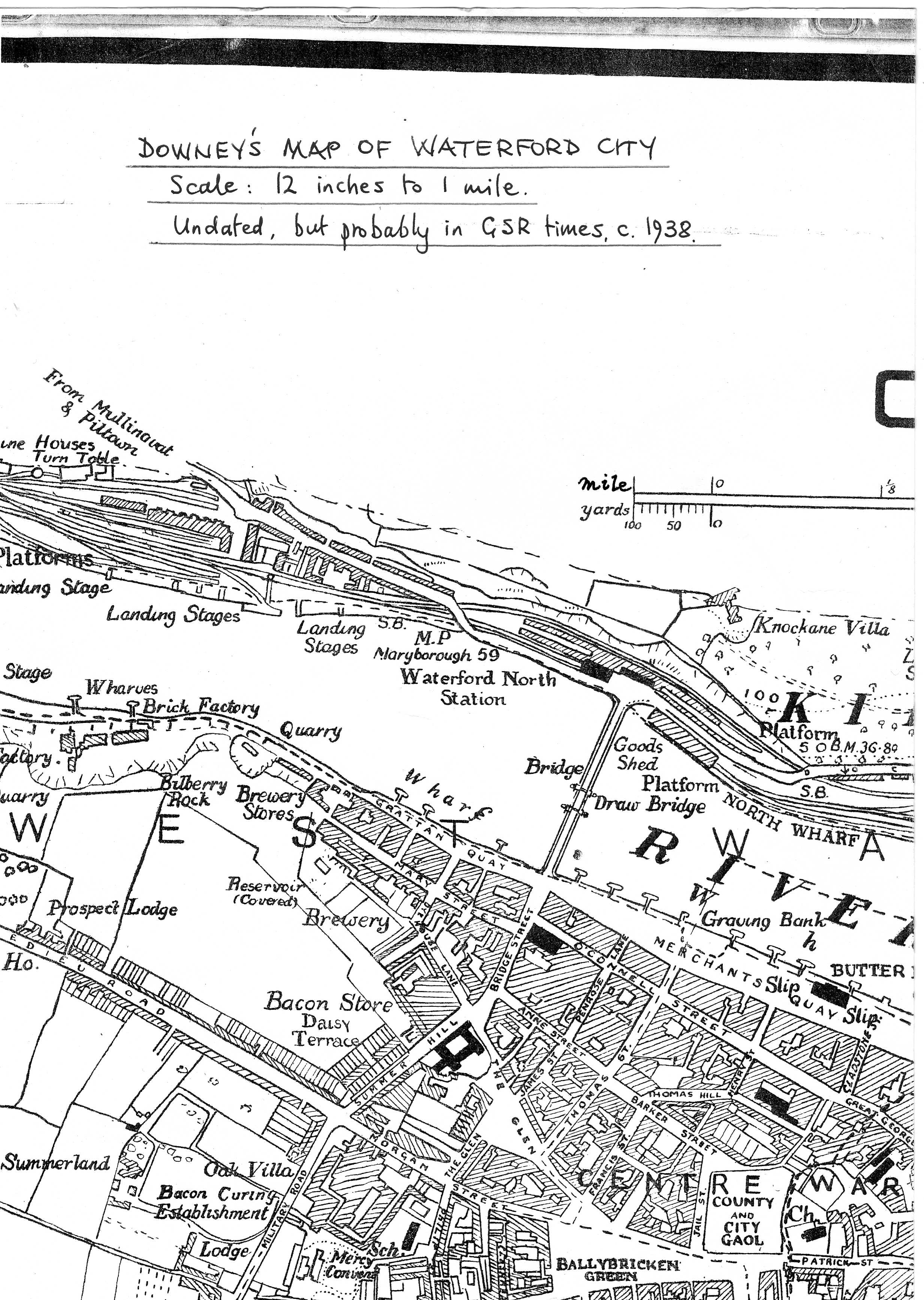
Downey's hand-drawn map of Waterford City, which is undated but would appear to be in Great Southern Railway times before the 1939-45 Emergency. This part shows the railway station on the north bank, along with the port installations on both sides of the Suir estuary. Courtesy of Waterford City Library 2005. |
John Swain |
Monday 13th of October 2014 02:21:16 PM |
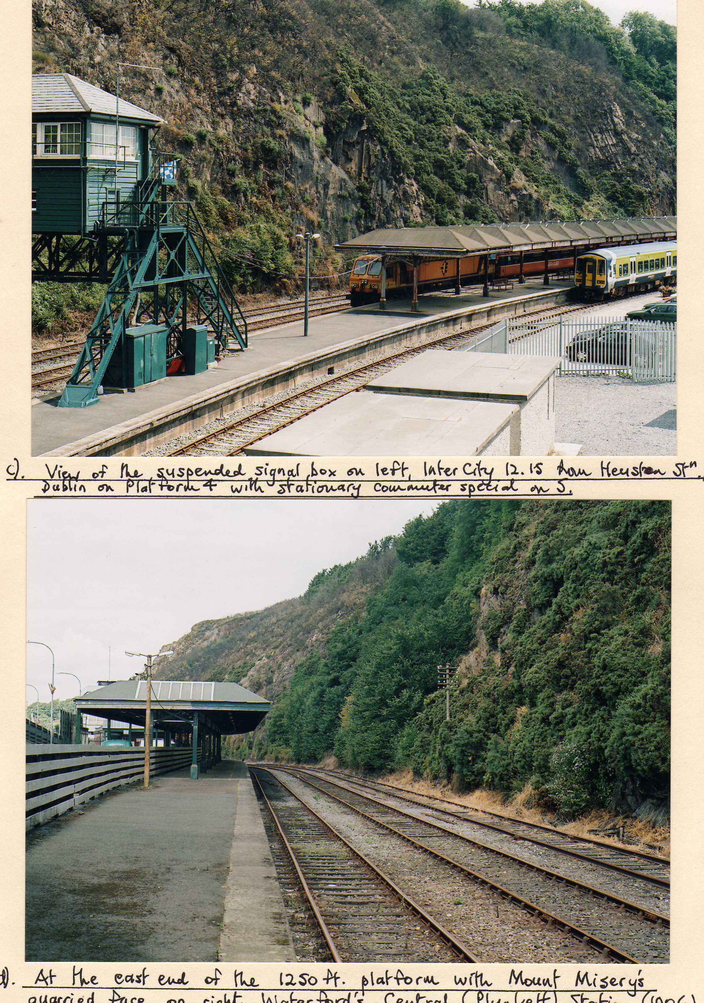
The much-changed Waterford Station, renamed Plunkett in 1966, with a view of the suspended signal box on the left in the top image and an Inter-City destined for Dublin Heuston station on platform 4 and a local commuter train on 5. In the lower picture, the quarried face of Mount Misery is readily apparent on the right hand side in this view of the eastern end of the station. The tracks used to lead to New Ross (closed to passengers in 1963) and Rosslare (closed in 2011). Both pictures were taken by the contributor in September 2005. |
John Swain |
Monday 13th of October 2014 02:12:22 PM |