
Scheduled Maintenance
This website will undergo scheduled maintenance on Tuesday, September 10th, between 11:00 and 15:00, as well as on Thursday, September 12th, between 10:00 and 12:00. During this time, services may be temporarily disrupted. We apologise for any inconvenience.
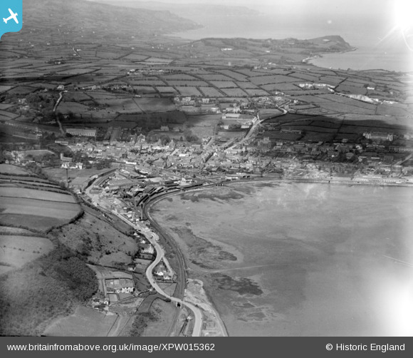
xpw015362 NORTHERN IRELAND (1926). Town and Bay, Larne, Larne, Northern Ireland, 1926. Oblique aerial photograph taken facing North.
© Copyright OpenStreetMap contributors and licensed by the OpenStreetMap Foundation. 2024. Cartography is licensed as CC BY-SA.
Nearby Images (2)
XPW015362

XPW015361

Details
| Title | [XPW015362] Town and Bay, Larne, Larne, Northern Ireland, 1926. Oblique aerial photograph taken facing North. |
| Reference | XPW015362 |
| Date | 1926 |
| Link | |
| Place name | LARNE |
| Parish | NORTHERN IRELAND |
| District | |
| Country | NORTHERN IRELAND |
| Easting / Northing | 155201, 557353 |
| Longitude / Latitude | -5.815088, 54.850945 |
| National Grid Reference |
Pins
 rcurrie |
Monday 30th of December 2019 03:05:06 PM | |
Stephen Craig |
Monday 1st of December 2014 01:49:57 PM | |
Stephen Craig |
Monday 1st of December 2014 01:48:23 PM |