
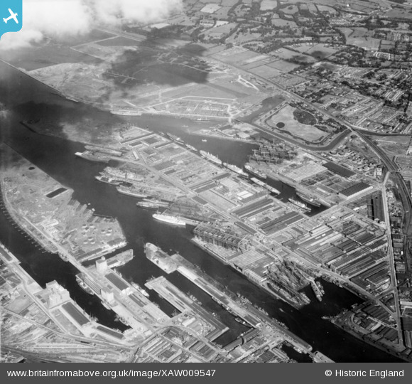
xaw009547 NORTHERN IRELAND (1947). Harland & Wolff, Belfast, Belfast, Northern Ireland, 1947. Oblique aerial photograph taken facing East.
© Copyright OpenStreetMap contributors and licensed by the OpenStreetMap Foundation. 2025. Cartography is licensed as CC BY-SA.
Nearby Images (9)
XAW009547

XAW009551

XPW043366

XAW009554

XAW009549

XAW009548

XAW009555

XAW009556

XPW043364

Details
| Title | [XAW009547] Harland & Wolff, Belfast, Belfast, Northern Ireland, 1947. Oblique aerial photograph taken facing East. |
| Reference | XAW009547 |
| Date | 15-August-1947 |
| Link | |
| Place name | BELFAST |
| Parish | NORTHERN IRELAND |
| District | |
| Country | NORTHERN IRELAND |
| Easting / Northing | 148332, 531137 |
| Longitude / Latitude | -5.899156, 54.612492 |
| National Grid Reference |
Pins
 DTopping |
Tuesday 19th of November 2024 12:27:19 PM | |
Jk |
Friday 9th of February 2024 03:44:44 PM | |
Jk |
Friday 9th of February 2024 03:43:57 PM | |
Jk |
Friday 9th of February 2024 03:38:58 PM | |
 Carlos Aneiro |
Wednesday 16th of March 2016 03:46:06 AM | |
Buzby |
Sunday 14th of December 2014 11:51:10 AM | |
Buzby |
Sunday 14th of December 2014 11:50:22 AM | |
Buzby |
Sunday 14th of December 2014 11:49:18 AM | |
Buzby |
Sunday 14th of December 2014 11:48:29 AM | |
Buzby |
Sunday 14th of December 2014 11:47:12 AM |