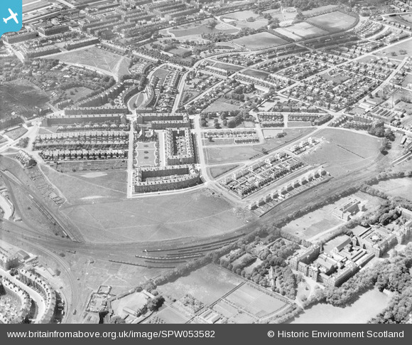
spw053582 SCOTLAND (1937). Glasgow, general view, showing Naseby Park and Victoria Park. An oblique aerial photograph taken facing west. This image has been produced from a print.
© Copyright OpenStreetMap contributors and licensed by the OpenStreetMap Foundation. 2024. Cartography is licensed as CC BY-SA.
Details
| Title | [SPW053582] Glasgow, general view, showing Naseby Park and Victoria Park. An oblique aerial photograph taken facing west. This image has been produced from a print. |
| Reference | SPW053582 |
| Date | 1937 |
| Link | Canmore Collection item 1315613 |
| Place name | |
| Parish | GOVAN (CITY OF GLASGOW) |
| District | CITY OF GLASGOW |
| Country | SCOTLAND |
| Easting / Northing | 254931, 667426 |
| Longitude / Latitude | -4.3191920291463, 55.878143217761 |
| National Grid Reference | NS549674 |
Pins
 tantrel |
Tuesday 12th of May 2020 11:34:29 AM | |
 tantrel |
Thursday 7th of November 2019 09:32:00 PM | |
 JIM |
Saturday 5th of December 2015 11:25:50 PM | |
 JIM |
Saturday 5th of December 2015 11:23:32 PM | |
 JIM |
Saturday 5th of December 2015 11:22:36 PM | |
 JIM |
Saturday 5th of December 2015 11:21:16 PM | |
 JIM |
Saturday 5th of December 2015 11:16:48 PM | |
 JIM |
Saturday 5th of December 2015 11:13:57 PM | |
 Alan McFarlane |
Thursday 19th of February 2015 08:50:11 PM | |
 David Bowd-Exworth |
Sunday 16th of November 2014 09:45:50 PM | |
 Sarah |
Monday 8th of July 2013 04:43:44 PM | |
 Sarah |
Monday 8th of July 2013 04:42:28 PM |

