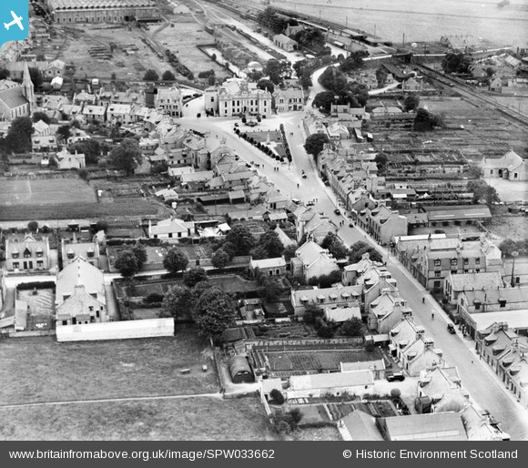
spw033662 SCOTLAND (1930). Inverurie, general view, showing High Street and Market Place. An oblique aerial photograph taken facing north.
© Copyright OpenStreetMap contributors and licensed by the OpenStreetMap Foundation. 2025. Cartography is licensed as CC BY-SA.
Details
| Title | [SPW033662] Inverurie, general view, showing High Street and Market Place. An oblique aerial photograph taken facing north. |
| Reference | SPW033662 |
| Date | 1930 |
| Link | Canmore Collection item 1257003 |
| Place name | |
| Parish | INVERURIE |
| District | GORDON |
| Country | SCOTLAND |
| Easting / Northing | 377568, 821394 |
| Longitude / Latitude | -2.3721284019483, 57.282823612355 |
| National Grid Reference | NJ776214 |
Pins
 KAW |
Saturday 12th of December 2020 09:41:37 PM | |
 Class31 |
Friday 5th of April 2013 09:53:36 AM | |
 Class31 |
Friday 5th of April 2013 09:46:13 AM | |
Not a school but Drill Hall, Jackson Street |
 John |
Monday 28th of December 2015 12:37:02 PM |
 Class31 |
Friday 5th of April 2013 09:43:54 AM | |
 Class31 |
Friday 5th of April 2013 09:42:45 AM | |
 Class31 |
Friday 5th of April 2013 09:40:50 AM | |
 Class31 |
Friday 5th of April 2013 09:40:18 AM | |
 Class31 |
Friday 5th of April 2013 09:39:36 AM | |
 Class31 |
Friday 5th of April 2013 09:39:15 AM | |
 Class31 |
Friday 5th of April 2013 09:37:13 AM | |
 Class31 |
Friday 5th of April 2013 09:35:52 AM | |
 Class31 |
Friday 5th of April 2013 09:35:00 AM |


![[SPW033662] Inverurie, general view, showing High Street and Market Place. An oblique aerial photograph taken facing north.](http://britainfromabove.org.uk/sites/all/libraries/aerofilms-images/public/100x100/SPW/033/SPW033662.jpg)
![[SPW033656] Inverurie, general view, showing West High Street and Victoria Street. An oblique aerial photograph taken facing east. This image has been produced from a print.](http://britainfromabove.org.uk/sites/all/libraries/aerofilms-images/public/100x100/SPW/033/SPW033656.jpg)