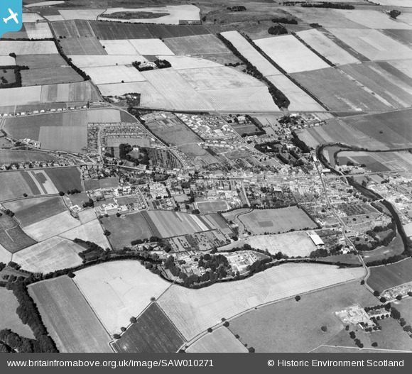
saw010271 SCOTLAND (1947). Haddington, general view, showing Neilson Park and Market Street. An oblique aerial photograph taken facing north.
© Copyright OpenStreetMap contributors and licensed by the OpenStreetMap Foundation. 2025. Cartography is licensed as CC BY-SA.
Details
| Title | [SAW010271] Haddington, general view, showing Neilson Park and Market Street. An oblique aerial photograph taken facing north. |
| Reference | SAW010271 |
| Date | 1947 |
| Link | Canmore Collection item 1268705 |
| Place name | |
| Parish | HADDINGTON |
| District | EAST LOTHIAN |
| Country | SCOTLAND |
| Easting / Northing | 351248, 673850 |
| Longitude / Latitude | -2.7808677540236, 55.95524049399 |
| National Grid Reference | NT512739 |
Pins
 PJ Wright |
Tuesday 10th of July 2012 12:37:25 AM |


![[SAW010271] Haddington, general view, showing Neilson Park and Market Street. An oblique aerial photograph taken facing north.](http://britainfromabove.org.uk/sites/all/libraries/aerofilms-images/public/100x100/SAW/010/SAW010271.jpg)
![[SAR018912] General View Haddington, East Lothian, Scotland. An oblique aerial photograph taken facing South/East.](http://britainfromabove.org.uk/sites/all/libraries/aerofilms-images/public/100x100/SAR/018/SAR018912.jpg)
![[SAR018913] General View Haddington, East Lothian, Scotland. An oblique aerial photograph taken facing North. This image was marked by AeroPictorial Ltd for photo editing.](http://britainfromabove.org.uk/sites/all/libraries/aerofilms-images/public/100x100/SAR/018/SAR018913.jpg)
![[SAW010272] Haddington, general view, showing Town House and High Street. An oblique aerial photograph taken facing west.](http://britainfromabove.org.uk/sites/all/libraries/aerofilms-images/public/100x100/SAW/010/SAW010272.jpg)