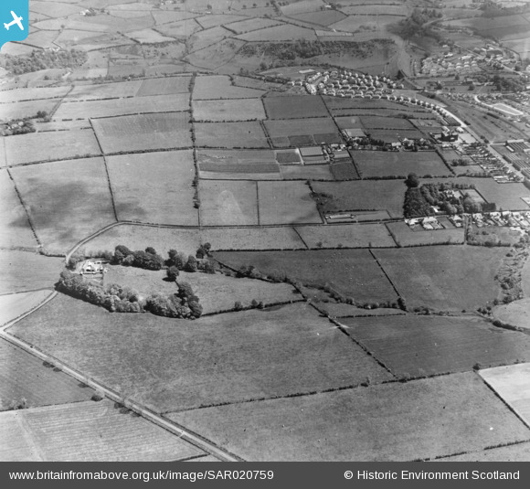
sar020759 SCOTLAND (1954). Laigh Braidley Farm, near Darvel Galston, Ayrshire, Scotland. An oblique aerial photograph taken facing East.
© Copyright OpenStreetMap contributors and licensed by the OpenStreetMap Foundation. 2024. Cartography is licensed as CC BY-SA.
Details
| Title | [SAR020759] Laigh Braidley Farm, near Darvel Galston, Ayrshire, Scotland. An oblique aerial photograph taken facing East. |
| Reference | SAR020759 |
| Date | 1954 |
| Link | Canmore Collection item 1438230 |
| Place name | |
| Parish | LOUDOUN |
| District | KILMARNOCK AND LOUDOUN |
| Country | SCOTLAND |
| Easting / Northing | 256500, 637500 |
| Longitude / Latitude | -4.2784123327335, 55.60990850044 |
| National Grid Reference | NS565375 |
Pins
 [eBay} - Copy_0.jpg) ChesterMan |
Thursday 23rd of October 2014 03:03:34 PM | |
 [eBay} - Copy_0.jpg) ChesterMan |
Thursday 23rd of October 2014 02:57:38 PM | |
 [eBay} - Copy_0.jpg) ChesterMan |
Thursday 23rd of October 2014 02:56:19 PM | |
 [eBay} - Copy_0.jpg) ChesterMan |
Thursday 23rd of October 2014 02:54:49 PM | |
 [eBay} - Copy_0.jpg) ChesterMan |
Thursday 23rd of October 2014 02:52:47 PM | |
 [eBay} - Copy_0.jpg) ChesterMan |
Thursday 23rd of October 2014 02:49:29 PM | |
 [eBay} - Copy_0.jpg) ChesterMan |
Thursday 23rd of October 2014 02:48:50 PM | |
 [eBay} - Copy_0.jpg) ChesterMan |
Thursday 23rd of October 2014 02:48:11 PM | |
 [eBay} - Copy_0.jpg) ChesterMan |
Thursday 23rd of October 2014 02:46:55 PM | |
 [eBay} - Copy_0.jpg) ChesterMan |
Thursday 23rd of October 2014 02:45:30 PM | |
 [eBay} - Copy_0.jpg) ChesterMan |
Thursday 23rd of October 2014 02:43:25 PM | |
 [eBay} - Copy_0.jpg) ChesterMan |
Thursday 23rd of October 2014 02:41:08 PM | |
 [eBay} - Copy_0.jpg) ChesterMan |
Thursday 23rd of October 2014 02:39:26 PM | |
 [eBay} - Copy_0.jpg) ChesterMan |
Thursday 23rd of October 2014 02:36:23 PM | |
 [eBay} - Copy_0.jpg) ChesterMan |
Thursday 23rd of October 2014 02:34:21 PM | |
 [eBay} - Copy_0.jpg) ChesterMan |
Thursday 23rd of October 2014 02:33:22 PM | |
 [eBay} - Copy_0.jpg) ChesterMan |
Thursday 23rd of October 2014 02:30:28 PM | |
 [eBay} - Copy_0.jpg) ChesterMan |
Thursday 23rd of October 2014 02:28:28 PM | |
 [eBay} - Copy_0.jpg) ChesterMan |
Thursday 23rd of October 2014 02:26:10 PM | |
 [eBay} - Copy_0.jpg) ChesterMan |
Thursday 23rd of October 2014 02:25:43 PM | |
 [eBay} - Copy_0.jpg) ChesterMan |
Thursday 23rd of October 2014 02:25:01 PM |
User Comment Contributions
Building in the left centre foreground is Templehill 8 fig NGR - NS 5583 3844. Road in lower left corner is Foulpapple Road running up from NEWMILNS to the SW (right). The northern fringes of DARVEL form the right hand edge of the image as already detailed in the other Comment. Laigh Bradley Farm is not in this shot. It lies at least 1km to the north (left) of this image. The view is due East from roughly over Gamesland. |
 [eBay} - Copy_0.jpg) ChesterMan |
Thursday 23rd of October 2014 02:19:59 PM |

