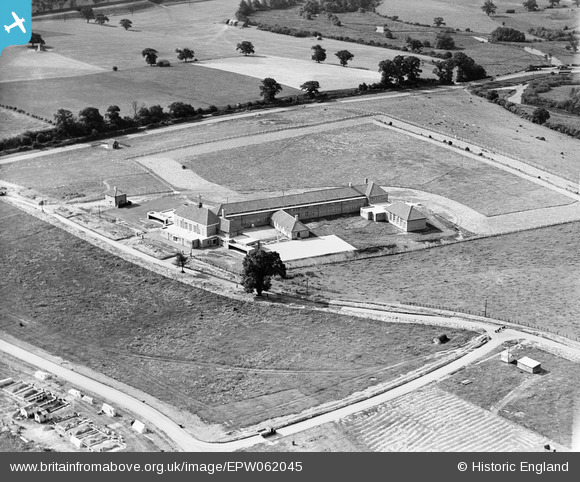
epw062045 ENGLAND (1939). Stanborough School, Welwyn Garden City, 1939
© Copyright OpenStreetMap contributors and licensed by the OpenStreetMap Foundation. 2025. Cartography is licensed as CC BY-SA.
Nearby Images (6)
Details
| Title | [EPW062045] Stanborough School, Welwyn Garden City, 1939 |
| Reference | EPW062045 |
| Date | 28-June-1939 |
| Link | |
| Place name | WELWYN GARDEN CITY |
| Parish | |
| District | |
| Country | ENGLAND |
| Easting / Northing | 522888, 211691 |
| Longitude / Latitude | -0.21803897339849, 51.789908806566 |
| National Grid Reference | TL229117 |
Pins
 Neil Hamilton |
Sunday 8th of December 2013 08:05:16 PM | |
So assuming this tree is now in the grounds of Police HQ? |
 SueB |
Sunday 10th of April 2016 10:56:07 PM |
 Neil Hamilton |
Sunday 8th of December 2013 08:04:48 PM | |
This tree also must be in Police HQs grounds. |
 SueB |
Sunday 10th of April 2016 10:57:06 PM |
 ColinM |
Friday 23rd of August 2013 05:15:18 PM | |
 ColinM |
Friday 23rd of August 2013 05:15:00 PM | |
 ColinM |
Friday 23rd of August 2013 05:14:22 PM | |
So this must be approx. the entrance road of the swimming pool..? |
 SueB |
Sunday 10th of April 2016 10:58:05 PM |


![[EPW062045] Stanborough School, Welwyn Garden City, 1939](http://britainfromabove.org.uk/sites/all/libraries/aerofilms-images/public/100x100/EPW/062/EPW062045.jpg)
![[EPW062044] Stanborough School, Welwyn Garden City, 1939](http://britainfromabove.org.uk/sites/all/libraries/aerofilms-images/public/100x100/EPW/062/EPW062044.jpg)
![[EPW047345] The town, Welwyn Garden City, from the south-west, 1935](http://britainfromabove.org.uk/sites/all/libraries/aerofilms-images/public/100x100/EPW/047/EPW047345.jpg)
![[EPW062068] Handside and the town centre, Welwyn Garden City, from the south-west, 1939](http://britainfromabove.org.uk/sites/all/libraries/aerofilms-images/public/100x100/EPW/062/EPW062068.jpg)
![[EPW062070] Handside and the town centre, Welwyn Garden City, from the south, 1939](http://britainfromabove.org.uk/sites/all/libraries/aerofilms-images/public/100x100/EPW/062/EPW062070.jpg)
![[EPW047346] The town, Welwyn Garden City, from the south-west, 1935](http://britainfromabove.org.uk/sites/all/libraries/aerofilms-images/public/100x100/EPW/047/EPW047346.jpg)