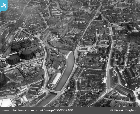
epw057400 ENGLAND (1938). Pensitone Road and environs, Sheffield, 1938. This image has been produced from a print.
© Copyright OpenStreetMap contributors and licensed by the OpenStreetMap Foundation. 2024. Cartography is licensed as CC BY-SA.
Nearby Images (10)
Details
| Title | [EPW057400] Pensitone Road and environs, Sheffield, 1938. This image has been produced from a print. |
| Reference | EPW057400 |
| Date | 3-June-1938 |
| Link | |
| Place name | SHEFFIELD |
| Parish | |
| District | |
| Country | ENGLAND |
| Easting / Northing | 434465, 388653 |
| Longitude / Latitude | -1.4816687684446, 53.393322602759 |
| National Grid Reference | SK345887 |
Pins
 Mick. |
Tuesday 8th of June 2021 07:55:13 AM | |
 Mick. |
Tuesday 8th of June 2021 07:54:38 AM | |
 Mick. |
Tuesday 8th of June 2021 07:53:49 AM | |
 Mick. |
Tuesday 8th of June 2021 07:52:52 AM | |
 Mick. |
Tuesday 8th of June 2021 07:51:00 AM | |
 Mick. |
Tuesday 8th of June 2021 07:50:40 AM | |
 Mick. |
Tuesday 8th of June 2021 07:46:57 AM | |
 Mick. |
Tuesday 8th of June 2021 07:45:34 AM | |
 Mick. |
Tuesday 8th of June 2021 07:44:19 AM | |
 Class31 |
Friday 13th of May 2016 07:40:22 AM | |
 Class31 |
Friday 13th of May 2016 07:35:20 AM | |
 Class31 |
Friday 13th of May 2016 07:31:19 AM | |
 Class31 |
Friday 13th of May 2016 07:26:00 AM | |
 Class31 |
Friday 13th of May 2016 07:22:22 AM |


![[EPW057400] Pensitone Road and environs, Sheffield, 1938. This image has been produced from a print.](http://britainfromabove.org.uk/sites/all/libraries/aerofilms-images/public/100x100/EPW/057/EPW057400.jpg)
![[EPW015488] The Neepsend Gas Works, Sheffield, 1926](http://britainfromabove.org.uk/sites/all/libraries/aerofilms-images/public/100x100/EPW/015/EPW015488.jpg)
![[EPW015494] The Neepsend Gas Works, Sheffield, 1926](http://britainfromabove.org.uk/sites/all/libraries/aerofilms-images/public/100x100/EPW/015/EPW015494.jpg)
![[EPW015484] The Neepsend Gas Works, Sheffield, 1926](http://britainfromabove.org.uk/sites/all/libraries/aerofilms-images/public/100x100/EPW/015/EPW015484.jpg)
![[EPW015598] The Neepsend Gas Works, Sheffield, 1926](http://britainfromabove.org.uk/sites/all/libraries/aerofilms-images/public/100x100/EPW/015/EPW015598.jpg)
![[EPW015597] The Neepsend Gas Works, Sheffield, 1926](http://britainfromabove.org.uk/sites/all/libraries/aerofilms-images/public/100x100/EPW/015/EPW015597.jpg)
![[EPW015493] The Neepsend Gas Works, Sheffield, 1926](http://britainfromabove.org.uk/sites/all/libraries/aerofilms-images/public/100x100/EPW/015/EPW015493.jpg)
![[EAW005029] The Hallamshire Steel and File Works alongside the Neepsend Gas Works, Sheffield, 1947](http://britainfromabove.org.uk/sites/all/libraries/aerofilms-images/public/100x100/EAW/005/EAW005029.jpg)
![[EAW005032] The Hallamshire Steel and File Works alongside the Neepsend Gas Works, Sheffield, 1947](http://britainfromabove.org.uk/sites/all/libraries/aerofilms-images/public/100x100/EAW/005/EAW005032.jpg)
![[EPW061499] Philadelphia, Sheffield, 1939](http://britainfromabove.org.uk/sites/all/libraries/aerofilms-images/public/100x100/EPW/061/EPW061499.jpg)