
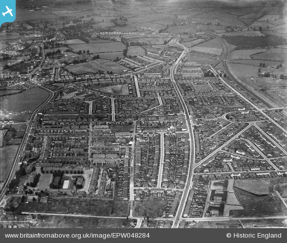
epw048284 ENGLAND (1935). The residential area surrounding Melton Crescent, Filton Avenue and Montreal Avenue, Horfield, 1935
© Copyright OpenStreetMap contributors and licensed by the OpenStreetMap Foundation. 2025. Cartography is licensed as CC BY-SA.
Nearby Images (3)
EPW048284

EPW048283

EPW048285

Details
| Title | [EPW048284] The residential area surrounding Melton Crescent, Filton Avenue and Montreal Avenue, Horfield, 1935 |
| Reference | EPW048284 |
| Date | July-1935 |
| Link | |
| Place name | HORFIELD |
| Parish | |
| District | |
| Country | ENGLAND |
| Easting / Northing | 360145, 177645 |
| Longitude / Latitude | -2.5741793367787, 51.495856316308 |
| National Grid Reference | ST601776 |
Pins

ian b jones |
Tuesday 2nd of July 2019 01:24:35 AM | |
|
Luke R |
Friday 14th of August 2015 12:34:43 AM | |
|
Geoff |
Monday 21st of July 2014 04:05:00 PM | |
|
Geoff |
Monday 21st of July 2014 03:55:26 PM | |
|
Clwyde |
Friday 15th of November 2013 06:45:31 PM | |
|
Clwyde |
Friday 15th of November 2013 06:41:06 PM | |
|
Clwyde |
Friday 15th of November 2013 06:39:30 PM | |
|
Clwyde |
Friday 15th of November 2013 06:34:47 PM | |

clippedwings |
Thursday 25th of July 2013 01:47:46 PM | |
Why "site of" ? Suggests something which isn't there but in this photo Horfield Station platforms are clearly visible if one zooms in. The station reopened April 1933 after the line up Filton bank was quadrupled. Closed Nov 1964. |
gBr |
Friday 28th of April 2017 01:06:42 PM |
|
clippedwings |
Thursday 25th of July 2013 01:44:38 PM | |
|
clippedwings |
Thursday 25th of July 2013 01:43:18 PM | |
|
Bristolian |
Tuesday 23rd of July 2013 01:05:23 PM | |
|
Bristolian |
Tuesday 23rd of July 2013 01:05:00 PM | |
|
kent2 |
Friday 19th of July 2013 01:35:26 PM | |
|
kent2 |
Saturday 6th of July 2013 12:45:42 PM | |
|
kent2 |
Saturday 6th of July 2013 12:44:38 PM | |
|
kent2 |
Saturday 6th of July 2013 12:43:24 PM | |
|
Isleworth1961 |
Tuesday 4th of June 2013 01:53:36 PM | |

Class31 |
Saturday 18th of May 2013 09:11:30 PM | |
|
Class31 |
Saturday 18th of May 2013 09:10:30 PM | |
|
Class31 |
Saturday 18th of May 2013 09:09:45 PM |


User Comment Contributions
The line of white semi-detached houses at the top of the image below the Conygre House tag is Wades Road. |
Geoff |
Tuesday 17th of June 2014 07:33:55 PM |