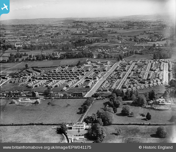
epw041175 ENGLAND (1933). Housing off Burnthouse Lane and environs, Exeter, from the south-west, 1933
© Copyright OpenStreetMap contributors and licensed by the OpenStreetMap Foundation. 2025. Cartography is licensed as CC BY-SA.
Nearby Images (8)
Details
| Title | [EPW041175] Housing off Burnthouse Lane and environs, Exeter, from the south-west, 1933 |
| Reference | EPW041175 |
| Date | May-1933 |
| Link | |
| Place name | EXETER |
| Parish | |
| District | |
| Country | ENGLAND |
| Easting / Northing | 293617, 90954 |
| Longitude / Latitude | -3.5068223567877, 50.707901915338 |
| National Grid Reference | SX936910 |
Pins
 SBEES |
Sunday 6th of October 2024 07:46:26 PM | |
 SBEES |
Friday 4th of October 2024 12:50:56 PM | |
 SBEES |
Friday 4th of October 2024 12:24:40 PM | |
 SBEES |
Friday 4th of October 2024 12:23:22 PM | |
 SBEES |
Friday 4th of October 2024 12:22:14 PM | |
 SBEES |
Friday 4th of October 2024 12:03:05 PM | |
 SBEES |
Friday 4th of October 2024 11:59:40 AM | |
 David |
Friday 19th of August 2022 05:20:47 PM | |
Allen T |
Friday 29th of August 2014 04:03:03 PM | |
Allen T |
Friday 29th of August 2014 03:41:16 PM | |
Allen T |
Saturday 18th of May 2013 11:51:52 AM | |
Allen T |
Saturday 18th of May 2013 11:51:05 AM | |
Allen T |
Saturday 18th of May 2013 11:49:36 AM | |
Allen T |
Saturday 18th of May 2013 11:46:24 AM | |
Allen T |
Saturday 18th of May 2013 11:45:31 AM | |
Allen T |
Saturday 18th of May 2013 11:40:41 AM | |
Allen T |
Saturday 18th of May 2013 10:35:54 AM | |
Allen T |
Tuesday 14th of May 2013 11:25:50 AM | |
Allen T |
Tuesday 14th of May 2013 11:24:02 AM | |
Allen T |
Tuesday 14th of May 2013 11:20:47 AM | |
Allen T |
Tuesday 14th of May 2013 11:17:44 AM | |
Allen T |
Tuesday 14th of May 2013 11:15:57 AM | |
Allen T |
Tuesday 14th of May 2013 12:03:24 AM | |
Allen T |
Monday 13th of May 2013 11:57:21 PM | |
Allen T |
Monday 13th of May 2013 11:56:44 PM | |
Allen T |
Monday 13th of May 2013 11:56:05 PM | |
Allen T |
Monday 13th of May 2013 11:55:23 PM | |
Allen T |
Monday 13th of May 2013 11:54:44 PM | |
Allen T |
Monday 13th of May 2013 11:51:08 PM | |
Allen T |
Monday 13th of May 2013 11:50:13 PM | |
Allen T |
Monday 13th of May 2013 11:49:21 PM | |
Allen T |
Monday 13th of May 2013 11:48:32 PM | |
Allen T |
Monday 13th of May 2013 11:47:04 PM | |
Allen T |
Monday 13th of May 2013 11:46:15 PM | |
Allen T |
Monday 13th of May 2013 11:55:52 AM | |
Allen T |
Monday 13th of May 2013 11:54:11 AM | |
Allen T |
Monday 13th of May 2013 11:51:41 AM | |
Allen T |
Sunday 12th of May 2013 11:39:28 AM | |
Allen T |
Sunday 12th of May 2013 11:35:12 AM |
User Comment Contributions
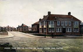
 The Dolphin Inn, newly built in Burnthouse Lane |
Allen T |
Saturday 18th of May 2013 10:44:34 AM |
An excellent example of the 1930's suburban sprawl into the countryside as the Garden City movement campaigned for better housing and residents in overcrowded, insanitary properties moved into new council housing. This photo shows the first phase of Exeter's Burnthouse Lane Housing Estate built to accommodate the removal of occupiers of Exeter's oldest area, the West Quarter, where infant mortality and death rates were amongst the worst in the UK and up to three times higher than the rest of the city. |
Allen T |
Tuesday 14th of May 2013 01:15:38 PM |


![[EPW041175] Housing off Burnthouse Lane and environs, Exeter, from the south-west, 1933](http://britainfromabove.org.uk/sites/all/libraries/aerofilms-images/public/100x100/EPW/041/EPW041175.jpg)
![[EAW033567] St Loyes College, Exeter, 1950. This image was marked by Aerofilms Ltd for photo editing.](http://britainfromabove.org.uk/sites/all/libraries/aerofilms-images/public/100x100/EAW/033/EAW033567.jpg)
![[EAW033575] St Loyes College, The Priory Secondary Modern School under construction and environs, Exeter, 1950. This image was marked by Aerofilms Ltd for photo editing.](http://britainfromabove.org.uk/sites/all/libraries/aerofilms-images/public/100x100/EAW/033/EAW033575.jpg)
![[EAW033574] St Loyes College and housing off Burnthouse Lane, Exeter, 1950. This image was marked by Aerofilms Ltd for photo editing.](http://britainfromabove.org.uk/sites/all/libraries/aerofilms-images/public/100x100/EAW/033/EAW033574.jpg)
![[EAW033572] St Loyes College and housing off Burnthouse Lane, Exeter, 1950. This image was marked by Aerofilms Ltd for photo editing.](http://britainfromabove.org.uk/sites/all/libraries/aerofilms-images/public/100x100/EAW/033/EAW033572.jpg)
![[EAW033571] St Loyes College and environs, Exeter, 1950. This image was marked by Aerofilms Ltd for photo editing.](http://britainfromabove.org.uk/sites/all/libraries/aerofilms-images/public/100x100/EAW/033/EAW033571.jpg)
![[EAW033570] St Loyes College and housing off Burnthouse Lane, Exeter, 1950. This image was marked by Aerofilms Ltd for photo editing.](http://britainfromabove.org.uk/sites/all/libraries/aerofilms-images/public/100x100/EAW/033/EAW033570.jpg)
![[EAW033573] St Loyes College and housing off Burnthouse Lane, Exeter, from the south-west, 1950. This image was marked by Aerofilms Ltd for photo editing.](http://britainfromabove.org.uk/sites/all/libraries/aerofilms-images/public/100x100/EAW/033/EAW033573.jpg)
