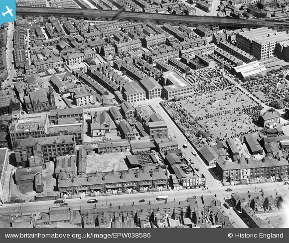
epw038586 ENGLAND (1932). The Atlas Ink Works, the Ardwick Cemetery and environs, Ardwick, 1932
© Copyright OpenStreetMap contributors and licensed by the OpenStreetMap Foundation. 2024. Cartography is licensed as CC BY-SA.
Nearby Images (6)
Details
| Title | [EPW038586] The Atlas Ink Works, the Ardwick Cemetery and environs, Ardwick, 1932 |
| Reference | EPW038586 |
| Date | June-1932 |
| Link | |
| Place name | ARDWICK |
| Parish | |
| District | |
| Country | ENGLAND |
| Easting / Northing | 385549, 397117 |
| Longitude / Latitude | -2.2177261871483, 53.47033694646 |
| National Grid Reference | SJ855971 |
Pins
 elltrain3 |
Saturday 17th of August 2024 06:16:40 PM | |
 a.darby |
Monday 7th of September 2020 10:27:38 PM | |
 john keenan |
Saturday 18th of January 2020 10:17:00 AM | |
 john keenan |
Saturday 18th of January 2020 09:36:27 AM | |
 JJH |
Thursday 25th of August 2016 10:00:19 PM | |
 JJH |
Thursday 25th of August 2016 09:56:27 PM | |
 JJH |
Thursday 25th of August 2016 09:55:44 PM | |
 JJH |
Thursday 25th of August 2016 09:55:20 PM | |
 JJH |
Thursday 25th of August 2016 09:54:29 PM | |
 JJH |
Thursday 25th of August 2016 09:54:05 PM | |
 JJH |
Thursday 25th of August 2016 09:53:30 PM | |
 JJH |
Thursday 25th of August 2016 09:51:57 PM | |
 stardelta |
Thursday 7th of April 2016 07:55:00 PM | |
 John Wass |
Friday 15th of May 2015 08:19:04 PM | |
 trojanjohn |
Friday 1st of November 2013 02:33:37 PM | |
 trojanjohn |
Friday 1st of November 2013 02:33:02 PM |


![[EPW038586] The Atlas Ink Works, the Ardwick Cemetery and environs, Ardwick, 1932](http://britainfromabove.org.uk/sites/all/libraries/aerofilms-images/public/100x100/EPW/038/EPW038586.jpg)
![[EPW038583] The Atlas Ink Works, the Ardwick Cemetery and environs, Ardwick, 1932](http://britainfromabove.org.uk/sites/all/libraries/aerofilms-images/public/100x100/EPW/038/EPW038583.jpg)
![[EPW038585] The Atlas Ink Works, the Ardwick Cemetery and environs, Ardwick, 1932](http://britainfromabove.org.uk/sites/all/libraries/aerofilms-images/public/100x100/EPW/038/EPW038585.jpg)
![[EPW038582] The Atlas Ink Works and environs, Ardwick, 1932](http://britainfromabove.org.uk/sites/all/libraries/aerofilms-images/public/100x100/EPW/038/EPW038582.jpg)
![[EPW038587] The Atlas Ink Works and environs, Ardwick, 1932](http://britainfromabove.org.uk/sites/all/libraries/aerofilms-images/public/100x100/EPW/038/EPW038587.jpg)
![[EPW038584] The Atlas Ink Works, the Ardwick Cemetery and environs, Ardwick, 1932](http://britainfromabove.org.uk/sites/all/libraries/aerofilms-images/public/100x100/EPW/038/EPW038584.jpg)