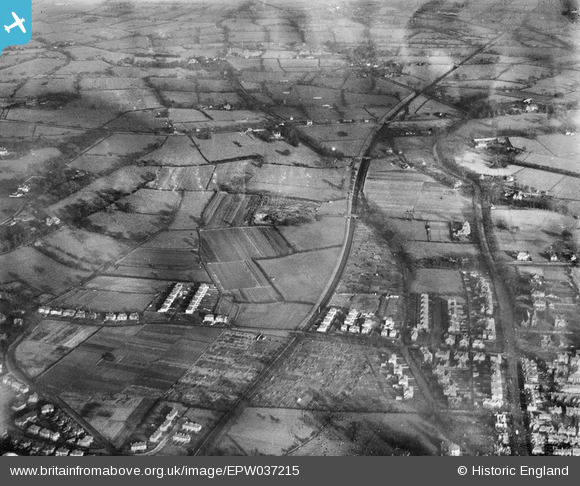
epw037215 ENGLAND (1931). Newton Hollows and environs, Newton, 1931

© Copyright OpenStreetMap contributors and licensed by the OpenStreetMap Foundation. 2024. Cartography is licensed as CC BY-SA.

Details

Title [EPW037215] Newton Hollows and environs, Newton, 1931
Reference EPW037215
Date November-1931
Link
Place name NEWTON
Parish
District
Country ENGLAND
Easting / Northing 341927, 368019
Longitude / Latitude -2.8695684753522, 53.205780297793
National Grid Reference SJ419680

Pins

Hoole Bank House. Now the Hammond Stage School. An article on its history is at https://thehammondschoolcentenary.wordpress.com/2017/01/05/hoole-bank-house-timeline/

ChesterMan
Wednesday 6th of March 2024 04:34:52 PM
Claypits of the Hoole Bank Brickworks and the future location of Hoole Bank acid tar lagoon. Clay for the brickworks was extracted from pits surrounding the works. This pin marks the largest, lying SSE of the works. After the brickworks closed in the mid 1930s, this pit was used to dump waste acid tar from the benzole refinery at Ellesmere Port. This continued until 1972. At least 62,000 tonnes of liquid acid tar was poured directly into the pit. In 2000 the contents of the pit were 44% sulphuric acid, 42% oil residues, 8% sulphated oil residues and 6% water. It covers an area of 1.1 ha, up to depths of 9m and is one of the largest acid tar pits in the world. As of 2021, environmental remediation of the site has not yet begun. [Source: ChesterWiki]

ChesterMan
Wednesday 6th of March 2024 04:30:09 PM
Hoole Bank Brickworks. The chimney is very clearly seen. The brickworks were built around 1900 and operated until around 1934. The clay was quarried from the land immediately surrounding the works. The bricks manufactured would not be of the high quality Ruabon type used as facing in much 1890's building in Hoole, but of a lower-cost single-fired variety. These would be used as an alternative to Ruabon brick for lower-cost housing and for rear and interior walls. [Source: ChesterWiki article]. Until 1967, the abandoned claypits were used to dump highly toxic acid tar waste from the benzole refinery in Ellesmere Port. See the Pin placed on the pit for more information.

ChesterMan
Wednesday 6th of March 2024 04:10:47 PM
Field House, to the north of Mannings Lane. Immediately to the west is now the Cheshire County Officers Cricket Club ground.

ChesterMan
Wednesday 6th of March 2024 03:30:28 PM
This hedge line now forms the rear boundaries of the properties on the west side of Coniston Road and the southern end of Kent Road. The semi-detached houses on the west side of Kent Road were built in the winter of 1959-60. The field to the west is now a rugby pitch on the University of Chester Kingsway Campus. The campus was formerly Kingsway High School.

ChesterMan
Wednesday 6th of March 2024 03:07:28 PM
Future location of the Co-operative supermarket at the south-east corner of the Kingsway shopping parade. The parade forms an L-shape extending westwards towards the Dee Miller public house.

ChesterMan
Wednesday 6th of March 2024 03:02:06 PM
This short lane became the northern end of the modern Coniston Road

ChesterMan
Wednesday 6th of March 2024 02:56:11 PM
Future location of the Dee Miller public house on Coniston Road

ChesterMan
Wednesday 6th of March 2024 02:48:05 PM

ChesterMan
Wednesday 6th of March 2024 02:36:05 PM
Long Lane (A41)

ChesterMan
Wednesday 6th of March 2024 02:29:05 PM
Greenfield Lane (A41)

ChesterMan
Wednesday 6th of March 2024 02:28:04 PM
Newton Bank (now demolished)

ChesterMan
Wednesday 6th of March 2024 02:23:19 PM
Newton Corner (the local name for the junction of Newton Lane with Hoole Road)

ChesterMan
Wednesday 6th of March 2024 02:06:55 PM

ChesterMan
Wednesday 6th of March 2024 02:05:21 PM
Western Approach

ChesterMan
Wednesday 6th of March 2024 02:04:31 PM

ChesterMan
Wednesday 6th of March 2024 02:02:55 PM

ChesterMan
Wednesday 6th of March 2024 02:02:06 PM
Alexandra Terrace

dd
Friday 14th of April 2023 10:01:42 AM
Shrubland Villa

dd
Friday 14th of April 2023 10:00:50 AM

dd
Friday 14th of April 2023 10:00:25 AM

staffsmod
Friday 4th of October 2013 02:15:29 PM
Shavington Avenue

old parkonian
Wednesday 11th of September 2013 10:29:11 AM
All Saints Church, Hoole

Bunn72
Friday 6th of September 2013 08:46:52 PM
Hoole Hall (now rebranded as the DoubleTree by Hilton Hotel & Spa, Chester)

Bunn72
Friday 6th of September 2013 08:45:48 PM

Bunn72
Wednesday 22nd of May 2013 12:30:01 PM

Bunn72
Wednesday 22nd of May 2013 12:28:51 PM
Plas Newton Lane

Bunn72
Wednesday 22nd of May 2013 12:28:28 PM
Manning Lane South

Bunn72
Saturday 18th of May 2013 08:13:49 PM
Newton Hollows. The course of the original northward road from Chester. The route was superseded by the Hoole Road turnpike in the 18th century.

Bunn72
Saturday 18th of May 2013 08:12:30 PM

Bunn72
Saturday 18th of May 2013 08:10:16 PM

Bunn72
Saturday 18th of May 2013 08:09:54 PM

Bunn72
Saturday 18th of May 2013 08:09:20 PM