
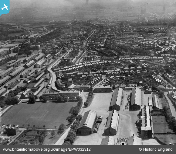
epw032312 ENGLAND (1930). The South Cavalry Barracks and the town centre, Aldershot, from the west, 1930
© Copyright OpenStreetMap contributors and licensed by the OpenStreetMap Foundation. 2026. Cartography is licensed as CC BY-SA.
Details
| Title | [EPW032312] The South Cavalry Barracks and the town centre, Aldershot, from the west, 1930 |
| Reference | EPW032312 |
| Date | 5-June-1930 |
| Link | |
| Place name | ALDERSHOT |
| Parish | |
| District | |
| Country | ENGLAND |
| Easting / Northing | 485465, 150638 |
| Longitude / Latitude | -0.77534572321621, 51.247989737564 |
| National Grid Reference | SU855506 |
Pins

Charlotte Colmans |
Thursday 25th of April 2024 08:49:48 PM | |
|
DavidB |
Wednesday 31st of August 2022 07:04:55 PM | |
|
The Laird |
Monday 13th of July 2015 12:50:34 PM | |
|
The Laird |
Monday 13th of July 2015 12:46:34 PM | |
|
David960 |
Monday 9th of February 2015 06:49:09 PM | |
|
David960 |
Monday 9th of February 2015 06:45:56 PM | |
|
The Laird |
Sunday 29th of June 2014 06:41:14 PM | |
|
Chapster62 |
Monday 11th of November 2013 03:54:30 PM | |
|
Chapster62 |
Monday 11th of November 2013 03:53:56 PM | |
|
Chapster62 |
Monday 11th of November 2013 03:53:33 PM | |
|
flubber |
Wednesday 29th of May 2013 06:46:12 PM | |
|
flubber |
Wednesday 29th of May 2013 06:45:08 PM | |
|
flubber |
Wednesday 29th of May 2013 06:43:19 PM | |
|
flubber |
Wednesday 29th of May 2013 06:42:12 PM | |
|
flubber |
Wednesday 29th of May 2013 06:41:26 PM | |
No, I don't think so. South Cavalry Barracks was Beaumont Barracks. Your marker is at a point where Willems Barracks, (West Cavalry Barracks) and Warburg Barracks (East Cavalry Barracks) meet. |
The Laird |
Sunday 29th of June 2014 06:38:18 PM |
|
flubber |
Wednesday 29th of May 2013 06:40:50 PM |