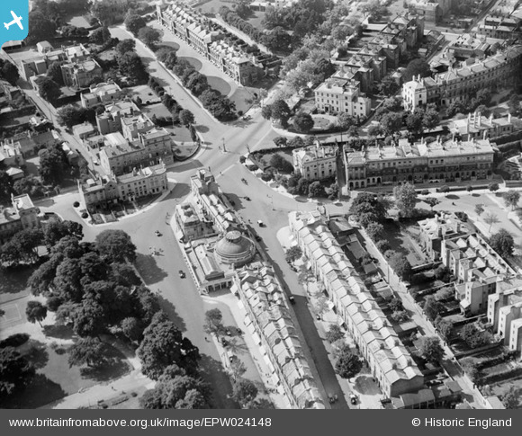
epw024148 ENGLAND (1928). The junction of Lansdown Place and Montpellier Street, Cheltenham, 1928
© Copyright OpenStreetMap contributors and licensed by the OpenStreetMap Foundation. 2024. Cartography is licensed as CC BY-SA.
Nearby Images (5)
Details
| Title | [EPW024148] The junction of Lansdown Place and Montpellier Street, Cheltenham, 1928 |
| Reference | EPW024148 |
| Date | September-1928 |
| Link | |
| Place name | CHELTENHAM |
| Parish | |
| District | |
| Country | ENGLAND |
| Easting / Northing | 394360, 221819 |
| Longitude / Latitude | -2.0819704747219, 51.894454848414 |
| National Grid Reference | SO944218 |
Pins
 John Stephenson |
Saturday 22nd of November 2014 12:06:52 AM | |
 Class31 |
Saturday 28th of September 2013 12:03:31 PM | |
 John Stephenson |
Friday 21st of June 2013 03:05:58 PM | |
 John Stephenson |
Friday 21st of June 2013 03:04:39 PM | |
 Class31 |
Tuesday 16th of October 2012 03:46:39 PM | |
 Class31 |
Tuesday 16th of October 2012 03:45:24 PM | |
 Class31 |
Tuesday 16th of October 2012 03:44:49 PM | |
 Class31 |
Tuesday 16th of October 2012 03:43:50 PM | |
 Class31 |
Tuesday 16th of October 2012 03:43:20 PM | |
 Class31 |
Tuesday 16th of October 2012 03:42:37 PM | |
 Class31 |
Tuesday 16th of October 2012 03:42:06 PM | |
 Class31 |
Tuesday 16th of October 2012 03:40:48 PM | |
 Class31 |
Tuesday 16th of October 2012 03:40:11 PM |
User Comment Contributions
Exterior of the Montpellier Rotunda which is now Lloyds Bank 27/09/2013 |
 Class31 |
Saturday 28th of September 2013 12:07:48 PM |


![[EPW024148] The junction of Lansdown Place and Montpellier Street, Cheltenham, 1928](http://britainfromabove.org.uk/sites/all/libraries/aerofilms-images/public/100x100/EPW/024/EPW024148.jpg)
![[EPW024144] Lansdown Crescent and environs, Cheltenham, 1928. This image has been produced from a copy-negative.](http://britainfromabove.org.uk/sites/all/libraries/aerofilms-images/public/100x100/EPW/024/EPW024144.jpg)
![[EPR000387] Lansdown Place and environs, Lansdown, 1934](http://britainfromabove.org.uk/sites/all/libraries/aerofilms-images/public/100x100/EPR/000/EPR000387.jpg)
![[EPW048206] The Winter Garden, Montpellier Gardens and the town, Cheltenham, from the south-west, 1935](http://britainfromabove.org.uk/sites/all/libraries/aerofilms-images/public/100x100/EPW/048/EPW048206.jpg)
![[EAW006514] Ashburne Bowling Green, St James' Church and Montpellier Gardens, Cheltenham, 1947](http://britainfromabove.org.uk/sites/all/libraries/aerofilms-images/public/100x100/EAW/006/EAW006514.jpg)