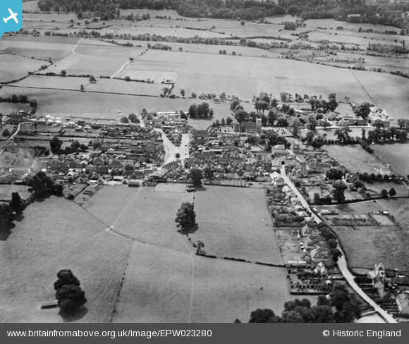
epw023280 ENGLAND (1928). The town centre, Thatcham, 1928
© Copyright OpenStreetMap contributors and licensed by the OpenStreetMap Foundation. 2025. Cartography is licensed as CC BY-SA.
Nearby Images (12)
Details
| Title | [EPW023280] The town centre, Thatcham, 1928 |
| Reference | EPW023280 |
| Date | September-1928 |
| Link | |
| Place name | THATCHAM |
| Parish | THATCHAM |
| District | |
| Country | ENGLAND |
| Easting / Northing | 451720, 167391 |
| Longitude / Latitude | -1.2563981385509, 51.402692871569 |
| National Grid Reference | SU517674 |
Pins

Class31 |
Sunday 3rd of November 2013 01:26:53 PM | |

Class31 |
Sunday 3rd of November 2013 12:46:13 PM | |

Class31 |
Sunday 3rd of November 2013 12:42:54 PM | |

Class31 |
Sunday 3rd of November 2013 12:40:20 PM | |

Class31 |
Sunday 3rd of November 2013 12:39:18 PM | |

Nickbits |
Wednesday 4th of July 2012 08:56:34 AM | |

Nickbits |
Wednesday 4th of July 2012 08:55:41 AM |


![[EPW023280] The town centre, Thatcham, 1928](http://britainfromabove.org.uk/sites/all/libraries/aerofilms-images/public/100x100/EPW/023/EPW023280.jpg)
![[EPW023278] Broadway, Thatcham, 1928](http://britainfromabove.org.uk/sites/all/libraries/aerofilms-images/public/100x100/EPW/023/EPW023278.jpg)
![[EPW036220] The town centre, Thatcham, 1931](http://britainfromabove.org.uk/sites/all/libraries/aerofilms-images/public/100x100/EPW/036/EPW036220.jpg)
![[EAW041723] The town centre, Thatcham, 1952](http://britainfromabove.org.uk/sites/all/libraries/aerofilms-images/public/100x100/EAW/041/EAW041723.jpg)
![[EAW041724] The town centre, Thatcham, 1952](http://britainfromabove.org.uk/sites/all/libraries/aerofilms-images/public/100x100/EAW/041/EAW041724.jpg)
![[EAW041725] The town, Thatcham, 1952. This image has been produced from a damaged negative.](http://britainfromabove.org.uk/sites/all/libraries/aerofilms-images/public/100x100/EAW/041/EAW041725.jpg)
![[EAW041726] The town centre, Thatcham, 1952. This image has been produced from a damaged negative.](http://britainfromabove.org.uk/sites/all/libraries/aerofilms-images/public/100x100/EAW/041/EAW041726.jpg)
![[EPW036223] St Mary's Church and the town centre, Thatcham, 1931](http://britainfromabove.org.uk/sites/all/libraries/aerofilms-images/public/100x100/EPW/036/EPW036223.jpg)
![[EPW036222] St Mary's Church, the Wood-Turning Works and town centre, Thatcham, 1931](http://britainfromabove.org.uk/sites/all/libraries/aerofilms-images/public/100x100/EPW/036/EPW036222.jpg)
![[EPW023279] The town centre, Thatcham, 1928](http://britainfromabove.org.uk/sites/all/libraries/aerofilms-images/public/100x100/EPW/023/EPW023279.jpg)
![[EPW023277] St Mary's Church and Wood Turning Works, Thatcham, 1928](http://britainfromabove.org.uk/sites/all/libraries/aerofilms-images/public/100x100/EPW/023/EPW023277.jpg)
![[EPW036226] St Mary's Church, Thatcham, 1931](http://britainfromabove.org.uk/sites/all/libraries/aerofilms-images/public/100x100/EPW/036/EPW036226.jpg)