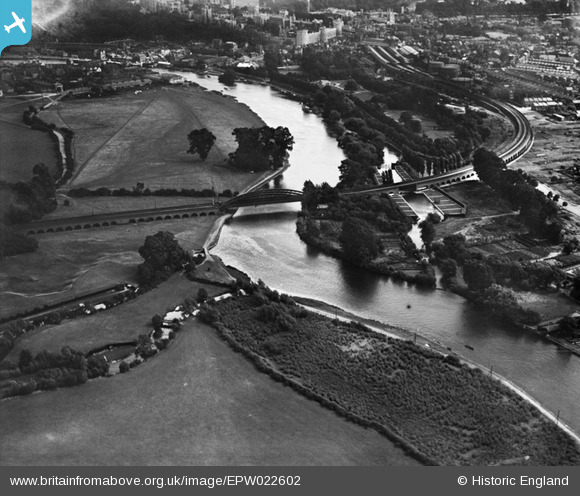
epw022602 ENGLAND (1928). Windsor Railway Bridge and Baths Island, Windsor, 1928
© Copyright OpenStreetMap contributors and licensed by the OpenStreetMap Foundation. 2025. Cartography is licensed as CC BY-SA.
Details
| Title | [EPW022602] Windsor Railway Bridge and Baths Island, Windsor, 1928 |
| Reference | EPW022602 |
| Date | 11-August-1928 |
| Link | |
| Place name | WINDSOR |
| Parish | |
| District | |
| Country | ENGLAND |
| Easting / Northing | 495999, 177346 |
| Longitude / Latitude | -0.61723108803747, 51.486421260696 |
| National Grid Reference | SU960773 |
Pins

Ellensdottir |
Sunday 10th of November 2013 03:50:14 PM | |

Ellensdottir |
Sunday 10th of November 2013 03:49:12 PM | |

Ellensdottir |
Sunday 10th of November 2013 03:48:18 PM | |

Ellensdottir |
Sunday 10th of November 2013 03:47:50 PM | |

Ellensdottir |
Sunday 10th of November 2013 03:47:13 PM | |

Ellensdottir |
Sunday 10th of November 2013 03:46:12 PM | |

Ellensdottir |
Sunday 10th of November 2013 03:45:48 PM | |

Ellensdottir |
Saturday 9th of November 2013 11:14:23 PM | |

MB |
Monday 22nd of October 2012 11:56:24 PM | |

dave43 |
Monday 9th of July 2012 01:28:49 PM | |
See EPW006215 a nearby view, where I have placed a pin for 'Athens', the Eton boys swimming area which was further upstream. |

Thamesweb |
Saturday 1st of September 2012 08:47:12 PM |
User Comment Contributions

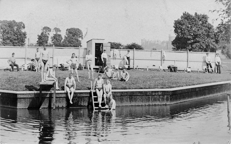
This is the view of soldiers enjoying a swim at the Cuckoo Weir bathing area. |

Thamesweb |
Thursday 3rd of October 2013 11:00:08 PM |
Windsor & Eton Central Station |

Class31 |
Monday 24th of June 2013 10:34:16 AM |
Great photo. My dad, his five brothers and two sisters learned to swim in the baths seen in the aerial view. My husband, his sister and brother, also learned their swimming skills in the old Windsor Swimming Baths as did their mother and her family. My generation never used the baths because they were deemed unsafe during an outbreak of polio. |

Pat Larkin |
Wednesday 4th of July 2012 05:39:36 PM |
The main areas of interest in this view are the swimming baths either side of the railway arches, and the poplar trees beyond. None of these trees survive these days although there were still some in the early 1960s. In 2012 the Sydney Camm Memorial, a replica Hurricane, was erected in this area. The baths were actually part of a back water of the Thames, around Baths Island. They are believed to have been created in 1904. In Victorian times the swimming area had been moved from this point further downstream, by Jacobs Island, as Queen Victoria did not believe the travelling public on the trains should see bathers undressed! After her death the baths were moved back to this part of the river. The river was not a healthy place to swim, the baths fell out of official use in the 1940s. It was not until 1963 that the first purpose built, War Memorial Swimming Pool was opened a short distance upstream from Baths Island, mainly due to the efforts of Cllr. Burton, on the site just up from the bottom R corner of this photograph. As of 2012 the concrete sides of the river bank remain but the changing cubicles have long gone. The white lines in this 1928 image are thought to be paths to the steps down into the river. In the centre of the RH bank is a diving board. To the right of the baths area there seems to be some works in progress. Certainly by the 1950s this area was a miniature golf course, with paths and a small watercourse. A short distance upstream the ISC boathouse would be opened on May 22nd 1934. This is shortly to be redeveloped as of 2012 providing improved boat facilities. |

Thamesweb |
Tuesday 3rd of July 2012 08:49:26 PM |


![[EPW022602] Windsor Railway Bridge and Baths Island, Windsor, 1928](http://britainfromabove.org.uk/sites/all/libraries/aerofilms-images/public/100x100/EPW/022/EPW022602.jpg)
![[EPW006215] View along the Thames from Deadwater Ait and Windsor Railway Bridge, Windsor, from the south-east, 1921](http://britainfromabove.org.uk/sites/all/libraries/aerofilms-images/public/100x100/EPW/006/EPW006215.jpg)
![[EPW031209] The River Thames flood covering South Field, the Eton Railway Viaduct and South Meadow, Eton, 1929](http://britainfromabove.org.uk/sites/all/libraries/aerofilms-images/public/100x100/EPW/031/EPW031209.jpg)